 Irish Spatial Data Exchange
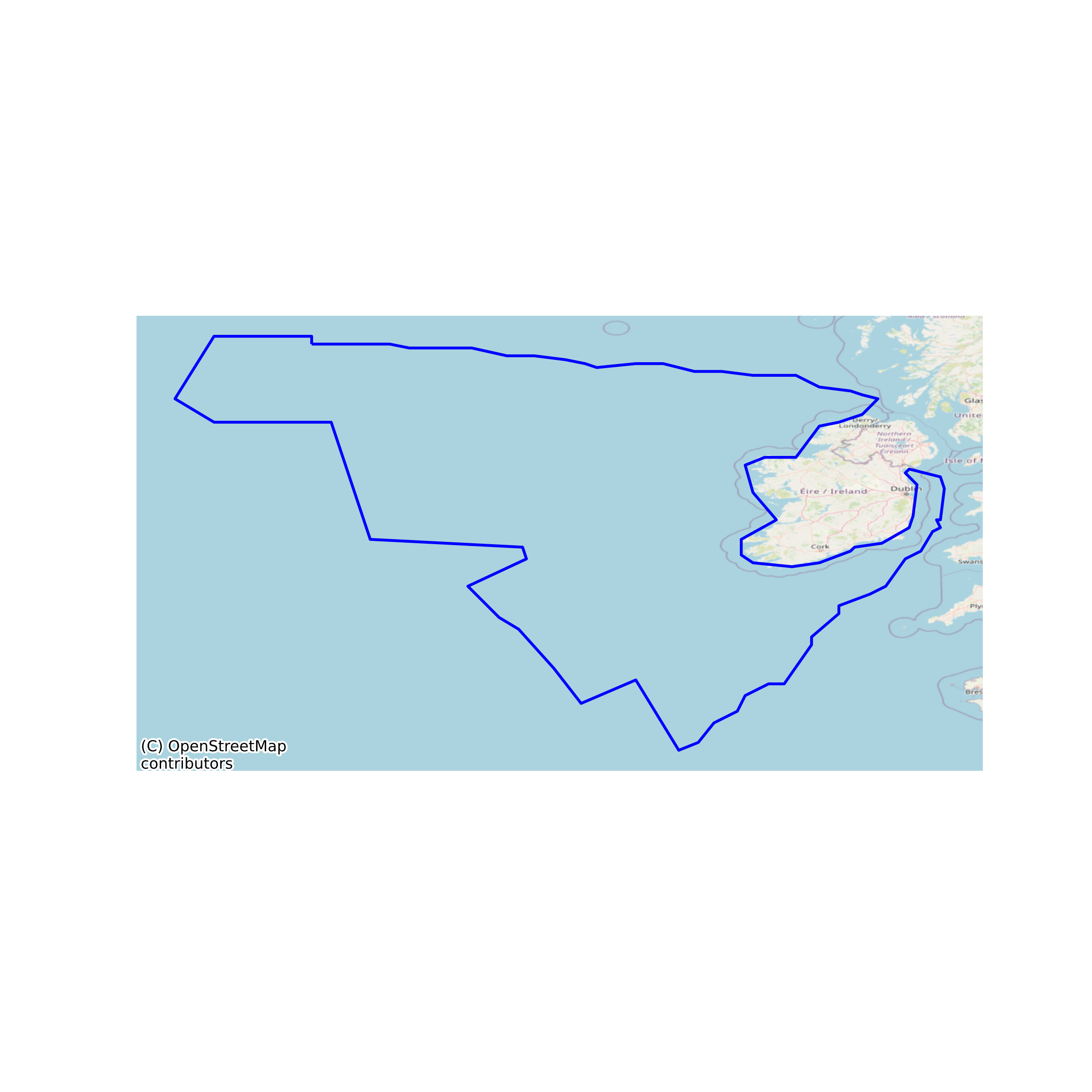
Currently Designated Irish Continental Shelf
The continental shelf is an underwater landmass which extends from a continent, resulting in an area of relatively shallow water known as a shelf sea. Much of the shelves were exposed during glacial periods and interglacial periods. The shelf surrounding an island is known as an insular shelf. The continental margin, between the continental shelf and the abyssal plain, comprises a steep continental slope followed by the flatter continental rise. Sediment from the continent above cascades down the slope and accumulates as a pile of sediment at the base of the slope, called the continental rise. Extending as far as 500 km (310 mi) from the slope, it consists of thick sediments deposited by turbidity currents from the shelf and slope. The continental rise's gradient is intermediate between the slope and the shelf, on the order of 0.5–1°. Under the United Nations Convention on the Law of the Sea, the name continental shelf was given a legal definition as the stretch of the seabed adjacent to the shores of a particular country to which it belongs. Area represents what is currently designated as the Irish Continental Shelf. None
Simple
- Date (Publication)
- 2017-10-18
- Date (Revision)
- 2023-06-01
- Date (Creation)
- 2017-10-18
- Citation identifier
- ie.marine.data:dataset.820
- Point of contact
-
Organisation name Individual name Electronic mail address Role None
None
Originator
- Maintenance and update frequency
- As needed
- Use limitation
-
While every effort is made in preparing the dataset no responsibility is accepted by or on behalf of the Marine Institute for any errors, omissions or misleading information. The Marine Institute accepts no responsibility for loss or damage occasioned or claimed to have been occasioned, in part or in full, as a consequence of any person acting, or refraining from acting as a result of a matter contained in this datasets or as a consequence of using this dataset for any purpose whatsoever.
- Spatial representation type
- Vector
- Language
- English
- Begin date
- 1993-03-29
- End date
- ..
))
- Reference system identifier
- INSPIRE RS registry / http://www.opengis.net/def/crs/EPSG/0/3857
- Distribution format
-
Name Version CSV
KML
Shapefile
- OnLine resource
-
Protocol Linkage Name WWW:DOWNLOAD-1.0-http--download
https://atlas.marine.ie/midata/AdministrativeUnits/Designated_Continental_Shelf.csv.zip CSV
- OnLine resource
-
Protocol Linkage Name WWW:DOWNLOAD-1.0-http--download
https://atlas.marine.ie/midata/AdministrativeUnits/Designated_Continental_Shelf.kml.zip KML
- OnLine resource
-
Protocol Linkage Name WWW:DOWNLOAD-1.0-http--download
https://atlas.marine.ie/midata/AdministrativeUnits/Designated_Continental_Shelf.shapezip.zip Shapefile
- Hierarchy level
- Dataset
Conformance result
- Title
-
Commission Regulation (EU) No 1089/2010 of 23 November 2010 implementing Directive 2007/2/EC of the European Parliament and of the Council as regards interoperability of spatial data sets and services
- Date (Publication)
- 2010-12-08
- Explanation
-
See the referenced specification
- Pass
- Yes
- Statement
-
Data supplied by Marine Institute.
Metadata
- File identifier
- ie.marine.data:dataset.820 XML
- Metadata language
- English
- Hierarchy level
- Dataset
- Date stamp
- 2023-06-01
- Metadata standard name
-
ISDI Metadata Profile
- Metadata standard version
-
1.2
- Metadata author
-
Organisation name Individual name Electronic mail address Role Marine Institute
Point of contact
)))
