 Irish Spatial Data Exchange
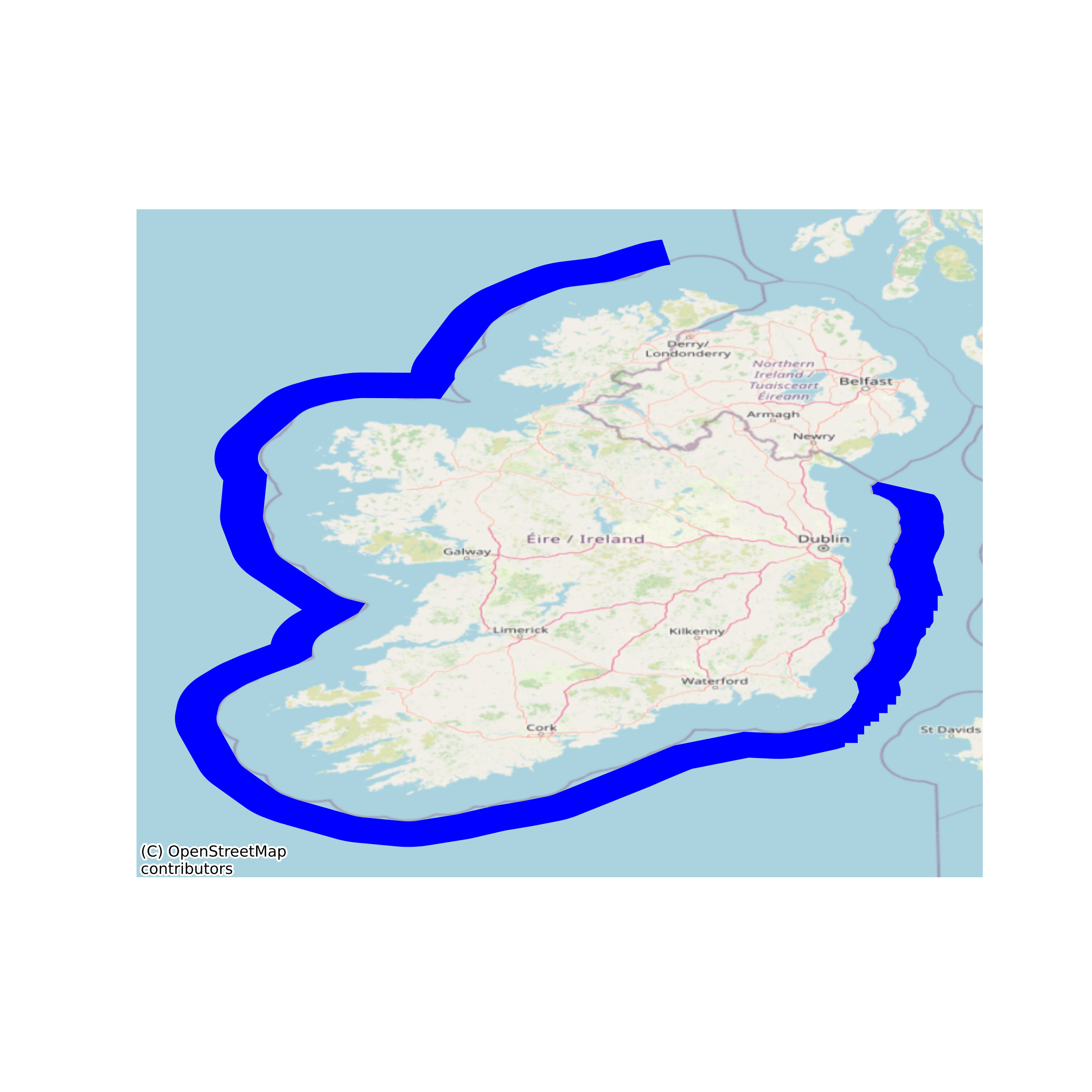
Irish Contiguous Zone
Beyond the 12-nautical-mile (22 km) limit, there is a further 12 nautical miles (22 km) from the territorial sea baseline limit, the contiguous zone, in which a state can continue to enforce laws in four specific areas: customs, taxation, immigration and pollution, if the infringement started within the state's territory or territorial waters, or if this infringement is about to occur within the state's territory or territorial waters. None
Simple
- Date (Publication)
- 2017-10-11
- Date (Revision)
- 2023-06-01
- Date (Creation)
- 2017-10-11
- Citation identifier
- ie.marine.data:dataset.797
- Point of contact
-
Organisation name Individual name Electronic mail address Role None
None
Originator
- Maintenance and update frequency
- As needed
- Use limitation
-
While every effort is made in preparing the dataset no responsibility is accepted by or on behalf of the Marine Institute for any errors, omissions or misleading information. The Marine Institute accepts no responsibility for loss or damage occasioned or claimed to have been occasioned, in part or in full, as a consequence of any person acting, or refraining from acting as a result of a matter contained in this datasets or as a consequence of using this dataset for any purpose whatsoever.
- Spatial representation type
- Vector
- Language
- English
- Begin date
- 2016-01-19
- End date
- ..
))
- Reference system identifier
- INSPIRE RS registry / http://www.opengis.net/def/crs/EPSG/0/3857
- Distribution format
-
Name Version CSV
KML
Shapefile
- OnLine resource
-
Protocol Linkage Name WWW:DOWNLOAD-1.0-http--download
https://atlas.marine.ie/midata/AdministrativeUnits/Contiguous_Zone.csv.zip CSV
- OnLine resource
-
Protocol Linkage Name WWW:DOWNLOAD-1.0-http--download
https://atlas.marine.ie/midata/AdministrativeUnits/Contiguous_Zone.kml.zip KML
- OnLine resource
-
Protocol Linkage Name WWW:DOWNLOAD-1.0-http--download
https://atlas.marine.ie/midata/AdministrativeUnits/Contiguous_Zone.shapezip.zip Shapefile
- Hierarchy level
- Dataset
Conformance result
- Title
-
Commission Regulation (EU) No 1089/2010 of 23 November 2010 implementing Directive 2007/2/EC of the European Parliament and of the Council as regards interoperability of spatial data sets and services
- Date (Publication)
- 2010-12-08
- Explanation
-
See the referenced specification
- Pass
- Yes
- Statement
-
Data supplied by Marine Institute.
Metadata
- File identifier
- ie.marine.data:dataset.797 XML
- Metadata language
- English
- Hierarchy level
- Dataset
- Date stamp
- 2023-06-01
- Metadata standard name
-
ISDI Metadata Profile
- Metadata standard version
-
1.2
- Metadata author
-
Organisation name Individual name Electronic mail address Role Marine Institute
Point of contact
)))
