 Irish Spatial Data Exchange
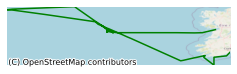
CE19009 Celtic Explorer Ocean Climate Survey Rockall Trough North East Atlantic Ocean 2019
The objective of this cruise was to collect high quality oceanographic data to contribute to the Atlantic Ocean Observing System. The Ocean Climate cruise facilitates long-term monitoring of the deep water environment to the west of Ireland. Oceanographic data collected contributes to the Atlantic Ocean Observing System and survey results are included in Ireland's national report submitted each year to the International Council for the Exploration of the Sea (ICES) Working Group on Oceanic Hydrography (WGOH). Each year, the survey data is submitted to the ICES Data Centre through the ICES WGOH. This WG produces an annual ICES Report on Ocean Climate (IROC) which summarises oceanic variability from year to year in the ICES region. Multidisciplinary information collected on the survey can support future reporting Marine Strategy Framework Directive (2008/56/EC), OSPAR Coordinated Environmental Monitoring Programme, Irish Climate Change assessments and national research efforts that focus on temporal dynamics of environmental variables in offshore deep territorial waters. The survey will also contribute to national research projects, for example, VOCAB, an Ocean Acidification and Biogeochemistry project, that focus on the temporal dynamics of environmental variables influenced by climate change related processes in offshore deeper territorial waters. The proposed continuation of the standard section will provide a time series to assess inter-annual variability of physical and biogeochemical conditions at the continental margin that impact on marginal ecosystems through many trophic levels. During the survey, 36 CTD (Conductivity, Temperature, Depth) profiles were taken at depths up to 3300m. Plankton samples were also taken at 21 stations. Chlorofluorocarbons (CFC) samples were collected for the first time on this survey which will be used to estimate ages of deep water masses in the Rockall Trough and to calculate the penetration of anthropogenic carbon. Two drifters were deployed, and one glider (which was later retrieved at the end of the survey). The M6 buoy was replaced with a new M6 buoy. The generation of long time series to monitor ocean climate is essential to create a baseline for climate studies and to understand the likely impact of future ocean climate scenarios on ecosystems and marine resources, e.g. fishing, aquaculture, environmental protection. Sustainability in these sectors was a key element in the in the Sea Change Strategy. The survey supports some of the needs stated in the “Climate Change” section of the recently published National Marine Research and Innovation Strategy 2017–2021. Capacity building: The team involved have spent the past decade developing the capacity to acquire this standard section data and to ensure that data is utilised quickly after collection. Improved understanding of ocean climate: The data collection on this cruise is designed to gather and establish baseline oceanic conditions in Irish waters that can be used to benchmark against future changes. Data gathered is used with time series from other sources (e.g. coastal databuoys, tide gauges). It is in this overall context that we can establish the oceanic baseline from which future changes can be assessed. Data collected also allows Ireland to contribute to Joint OSPAR/ICES Ocean Acidification Study Group reports. National strategic context: The proposed work outlined will underpin the delivery of elements of the Climate Change Programme under the National Marine Research and Innovation Strategy 2017–2021. Having reliable and consistent offshore data will support future reporting under the EU Marine Strategy Framework Directive. This survey will contribute to Action 13 of Harnessing Our Ocean Wealth – An Integrated Marine Plan for Ireland, which stresses the need to maintain and expand key marine observations for essential climate variables required to support improved regional climate modelling, forecasting and climate impact risk assessment.
Simple
- Date (Publication)
- 2021-08-03
- Date (Revision)
- 2023-06-01
- Date (Creation)
- 2021-08-03
- Citation identifier
- ie.marine.data:dataset.4738
- Point of contact
-
Organisation name Individual name Electronic mail address Role Marine Institute
Originator
- Maintenance and update frequency
- As needed
- Use limitation
-
While every effort is made in preparing the dataset no responsibility is accepted by or on behalf of the Marine Institute for any errors, omissions or misleading information. The Marine Institute accepts no responsibility for loss or damage occasioned or claimed to have been occasioned, in part or in full, as a consequence of any person acting, or refraining from acting as a result of a matter contained in this datasets or as a consequence of using this dataset for any purpose whatsoever.
- Use limitation
-
A Creative Commons (CC) license is one of several public copyright licenses that enable the free distribution of an otherwise copyrighted work. A CC license is used when an author wants to give people the right to share, use, and build upon a work that they have created. Under Creative Commons CC BY 4.0 the following is granted: Rights Share — copy and redistribute the material in any medium or format; Adapt — remix, transform, and build upon the material for any purpose, even commercially. The licensor cannot revoke these freedoms as long as you follow the license terms. Requirements Attribution — You must give appropriate credit, provide a link to the license, and indicate if changes were made. You may do so in any reasonable manner, but not in any way that suggests the licensor endorses you or your use. No additional restrictions — You may not apply legal terms or technological measures that legally restrict others from doing anything the license permits.
- Access constraints
- CC%20BY%204.0
- Aggregate Datasetindentifier
- ie.marine.data:platform.33
- Association Type
- Cross reference
- Initiative Type
- Platform
- Aggregate Datasetindentifier
- ie.marine.data:dataset.848
- Association Type
- Cross reference
- Initiative Type
- Collection
- Aggregate Datasetindentifier
- ie.marine.data:dataset.4014
- Association Type
- Cross reference
- Initiative Type
- Collection
- Aggregate Datasetindentifier
- ie.marine.data:dataset.845
- Association Type
- Cross reference
- Initiative Type
- Collection
- Spatial representation type
- Grid
- Language
- English
- Begin date
- 2019-05-24
- End date
- 2019-06-06
))
- Reference system identifier
- INSPIRE RS registry / http://www.opengis.net/def/crs/EPSG/0/3857
- Distribution format
-
Name Version CSV CTD Data
CSV Underway Data
CSV pCO2 Data
- OnLine resource
- OnLine resource
-
Protocol Linkage Name WWW:LINK-1.0-http--link
http://www.marine.ie
- Hierarchy level
- Dataset
Conformance result
- Title
-
Commission Regulation (EU) No 1089/2010 of 23 November 2010 implementing Directive 2007/2/EC of the European Parliament and of the Council as regards interoperability of spatial data sets and services
- Date (Publication)
- 2010-12-08
- Explanation
-
See the referenced specification
- Pass
- Yes
- Statement
-
Data supplied by Marine Institute.
Metadata
- File identifier
- ie.marine.data:dataset.4738 XML
- Metadata language
- English
- Hierarchy level
- Collection session
- Date stamp
- 2025-02-21T18:28:30.049809Z
- Metadata standard name
-
ISDI Metadata Profile
- Metadata standard version
-
1.2
- Metadata author
-
Organisation name Individual name Electronic mail address Role Marine Institute
Point of contact
)))
