 Irish Spatial Data Exchange
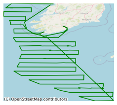
CE20008_1 Western European Shelf Pelagic Acoustic Survey (WESPAS) 2020 Leg 1
The WESPAS survey is an annual multi-disciplinary survey that is conducted by the Marine Institute to the west of Ireland and the British Isles from northern Bay of Biscay to the Hebrides from coastal waters out to the shelf edge. The survey is usually conducted over 2 legs in June and July each year. The objectives are to collect single (split) beam acoustic data on boarfish, herring, horse mackerel, sprat and mackerel aggregations within the pre-determined survey area. An age stratified estimate of biomass and abundance of the target species is generated from the survey data. Biological samples are collected from directed trawling on fish echotraces to determine age structure, size and maturity characteristics of the target stocks. Vertical CTD casts are deployed to determine hydrographic conditions and the extent of shelf frontal regions. Plankton samples using vertical net casts are used to determine biomass of zooplankton and the spatial extent of areas of distribution. Visual abundance surveys by observers for marine mammals and seabirds are also conducted throughout the survey area. Omni-directional sonar (Simrad SU90) is used to collect data on the aggregation morphology and behaviour of fish species. 43 CTDs were carried out during leg one of the survey. The main purpose of the cruise was to determine the relative abundance of the target species. This information is then used to determine catch rates and management advice for the following year.
Simple
- Date (Publication)
- 2021-07-20
- Date (Revision)
- 2021-07-20
- Date (Creation)
- 2021-07-20
- Citation identifier
- ie.marine.data:dataset.4701
- Point of contact
-
Organisation name Individual name Electronic mail address Role Marine Institute
Originator
- Maintenance and update frequency
- As needed
- Use limitation
-
While every effort is made in preparing the dataset no responsibility is accepted by or on behalf of the Marine Institute for any errors, omissions or misleading information. The Marine Institute accepts no responsibility for loss or damage occasioned or claimed to have been occasioned, in part or in full, as a consequence of any person acting, or refraining from acting as a result of a matter contained in this datasets or as a consequence of using this dataset for any purpose whatsoever.
- Use limitation
-
A Creative Commons (CC) license is one of several public copyright licenses that enable the free distribution of an otherwise copyrighted work. A CC license is used when an author wants to give people the right to share, use, and build upon a work that they have created. Under Creative Commons CC BY 4.0 the following is granted: Rights Share — copy and redistribute the material in any medium or format; Adapt — remix, transform, and build upon the material for any purpose, even commercially. The licensor cannot revoke these freedoms as long as you follow the license terms. Requirements Attribution — You must give appropriate credit, provide a link to the license, and indicate if changes were made. You may do so in any reasonable manner, but not in any way that suggests the licensor endorses you or your use. No additional restrictions — You may not apply legal terms or technological measures that legally restrict others from doing anything the license permits.
- Access constraints
- CC%20BY%204.0
- Aggregate Datasetindentifier
- ie.marine.data:platform.33
- Association Type
- Cross reference
- Initiative Type
- Platform
- Aggregate Datasetindentifier
- ie.marine.data:dataset.4014
- Association Type
- Cross reference
- Initiative Type
- Collection
- Aggregate Datasetindentifier
- ie.marine.data:dataset.845
- Association Type
- Cross reference
- Initiative Type
- Collection
- Spatial representation type
- Grid
- Language
- English
- Begin date
- 2020-06-02
- End date
- 2020-06-22
))
- Reference system identifier
- INSPIRE RS registry / http://www.opengis.net/def/crs/EPSG/0/3857
- Distribution format
-
Name Version CSV Underway Data
CSV pCO2 Data
- OnLine resource
- OnLine resource
-
Protocol Linkage Name WWW:LINK-1.0-http--link
http://www.marine.ie
- Hierarchy level
- Dataset
Conformance result
- Title
-
Commission Regulation (EU) No 1089/2010 of 23 November 2010 implementing Directive 2007/2/EC of the European Parliament and of the Council as regards interoperability of spatial data sets and services
- Date (Publication)
- 2010-12-08
- Explanation
-
See the referenced specification
- Pass
- Yes
- Statement
-
Data supplied by Marine Institute.
Metadata
- File identifier
- ie.marine.data:dataset.4701 XML
- Metadata language
- English
- Hierarchy level
- Collection session
- Date stamp
- 2025-02-21T18:28:29.679007Z
- Metadata standard name
-
ISDI Metadata Profile
- Metadata standard version
-
1.2
- Metadata author
-
Organisation name Individual name Electronic mail address Role Marine Institute
Point of contact
)))
