 Irish Spatial Data Exchange
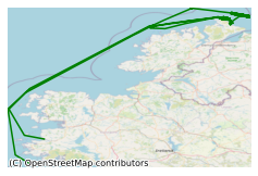
CE19008 MOnitoring CHAnge in Submarine CANyon Coral Habitats (MoCha_SCan) Leg 1North East Atlantic Ocean 2019
This 11 day survey led by University College Cork took place in May 2019 on board the RV Celtic Explorer in the North West Atlantic Ocean off the continental shelf. This survey focused on the maiden deployment of a number of novel, ROV-adapted lander systems in the Porcupine Bank Canyon (PBC) coral habitats, NE Atlantic. Cold water corals (CWCs) flourish on the Irish-Atlantic margin between 600 and 100 m water depth, where they form a number of structural habitat types (coral reefs, mounds and gardens). Recent research shows that deep water habitats, including CWC habitats on the Irish margin, may be impacted by recent environmental change. The main objectives of this survey are: a) to deploy 8 new lander systems within a range of coral habitats throughout the PBC; b) to complete mapping coverage within the PBC; c) to sample the coral, sediment and ambient watermass around the lander sites and; d) to sample particulate organic matter around key coral habitats. Data recorded via landers from each habitat will allow to determine the controls on habitat variability. Furthermore, this data can be used as a baseline to which later deployments at this site will be used to compare against. Completed canyon coverage will feed into a number of multiscale mapping projects including the H2020 project “Integrated Assessment of Atlantic Marine Ecosystems in Space and Time” (iATLANTIC) and the SFI-, GSI- and MI-funded “Mapping, Modelling and Monitoring Key Processes and Controls on Cold Water Coral Habitats in Submarine Canyons” (MMMonKey_Pro) programme. Video data will be used to characterise key coral habitat within the canyon and subsequesntly, HD DEM’s will be generated as a central dataset for the multiscale projects listed above. 1. To define high-resolution (1 - 20 m) temporal and spatial distribution of benthic boundary layer hydrodynamics processes influencing the canyon and associated habitats over a 3 month period (May - August). 2. To determine contemporary spatial and temporal sediment supply and distribution to the canyon and associated habitats (May - August). 3. To determine the specific factors controlling the type of habitat formed by cold water corals and associated organisms. 4. To determine active sedimentary processes within the Porcupine Bank Canyon, the furtherest westward canyon in Europe. 5. To determine the potential influence of nearby industrial impact (i.e. fisheries sediment plumes) on deep water benthic habitats. 6. To determine the anthropogenic finger print in suspended/contempory sediments (microplastics/faecal matter/pollutants) in deep water habitats offshore Ireland. 7. To generate a series of recommendations for site surveys by industrial activities to ensure responsible practice. 8. To determine the health status (diseases) of cold water corals in the Porcupine Bank Canyon. 9. To understand threshold and boundary conditions of cold water coral habitats. 10. To extend INFOMAR's spatial coverage of the Irish deepwater EEZ. During the survey 8 landers were deployed and 20 ROV dives took place. Water samples and push cores were taken at several of the lander sites. Multibeam seabed mapping of a wreck took place during the survey also.
Simple
- Date (Publication)
- 2021-06-29
- Date (Revision)
- 2023-06-01
- Date (Creation)
- 2021-06-29
- Citation identifier
- ie.marine.data:dataset.4659
- Point of contact
-
Organisation name Individual name Electronic mail address Role University College Cork
None
Originator
- Maintenance and update frequency
- As needed
- Use limitation
-
While every effort is made in preparing the dataset no responsibility is accepted by or on behalf of the Marine Institute for any errors, omissions or misleading information. The Marine Institute accepts no responsibility for loss or damage occasioned or claimed to have been occasioned, in part or in full, as a consequence of any person acting, or refraining from acting as a result of a matter contained in this datasets or as a consequence of using this dataset for any purpose whatsoever.
- Use limitation
-
A Creative Commons (CC) license is one of several public copyright licenses that enable the free distribution of an otherwise copyrighted work. A CC license is used when an author wants to give people the right to share, use, and build upon a work that they have created. Under Creative Commons CC BY 4.0 the following is granted: Rights Share — copy and redistribute the material in any medium or format; Adapt — remix, transform, and build upon the material for any purpose, even commercially. The licensor cannot revoke these freedoms as long as you follow the license terms. Requirements Attribution — You must give appropriate credit, provide a link to the license, and indicate if changes were made. You may do so in any reasonable manner, but not in any way that suggests the licensor endorses you or your use. No additional restrictions — You may not apply legal terms or technological measures that legally restrict others from doing anything the license permits.
- Access constraints
- CC%20BY%204.0
- Aggregate Datasetindentifier
- ie.marine.data:platform.33
- Association Type
- Cross reference
- Initiative Type
- Platform
- Aggregate Datasetindentifier
- ie.marine.data:dataset.4014
- Association Type
- Cross reference
- Initiative Type
- Collection
- Aggregate Datasetindentifier
- ie.marine.data:dataset.845
- Association Type
- Cross reference
- Initiative Type
- Collection
- Spatial representation type
- Grid
- Language
- English
- Begin date
- 2019-05-13
- End date
- 2019-05-23
))
- Reference system identifier
- INSPIRE RS registry / http://www.opengis.net/def/crs/EPSG/0/3857
- Distribution format
-
Name Version CSV Underway Data
CSV pCO2 Data
- OnLine resource
- OnLine resource
-
Protocol Linkage Name WWW:LINK-1.0-http--link
http://www.marine.ie
- Hierarchy level
- Dataset
Conformance result
- Title
-
Commission Regulation (EU) No 1089/2010 of 23 November 2010 implementing Directive 2007/2/EC of the European Parliament and of the Council as regards interoperability of spatial data sets and services
- Date (Publication)
- 2010-12-08
- Explanation
-
See the referenced specification
- Pass
- Yes
- Statement
-
Data supplied by Marine Institute.
Metadata
- File identifier
- ie.marine.data:dataset.4659 XML
- Metadata language
- English
- Hierarchy level
- Collection session
- Date stamp
- 2025-02-21T18:28:35.395697Z
- Metadata standard name
-
ISDI Metadata Profile
- Metadata standard version
-
1.2
- Metadata author
-
Organisation name Individual name Electronic mail address Role Marine Institute
Point of contact
)))
