 Irish Spatial Data Exchange
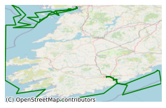
CV20016 Celtic Voyager Nephrops Underwater TV Survey Aran - Porcupine Grounds Northeast Atlantic Ocean 2020
CV20016 , the underwater television (UWTV) survey of abundance and distribution of Nephrops in the Celtic Sea Nephrops Grounds took place in June/July 2020 in the North East Atlantic Ocean on board the R.V. Celtic Voyager. All planned UWTV stations were surveyed successfully in the, Aran grounds and Galway Bay. Three stations were not surveyed in the Porcupine grounds. 30 hours of downtime was experiences due to poor weather conditions. Day grab samples were also collected for the Infomar seabed mapping project and for Galway Mayo Institute of Technology's (GMIT). Nephrops underwater television surveys are under the Data Collection Scheme, established under the European Union's (EU) Union Priority 3 (Fostering the Implementation of the Common Fisheries Policy) of Ireland’s Operational Programme which co-funded under the European Maritime and Fisheries Fund by the Irish Government and the EU. This dataset is used to assess the abundance of Nephrops norvegicus stock and provide management advice.
Simple
- Date (Publication)
- 2021-06-24
- Date (Revision)
- 2021-06-24
- Date (Creation)
- 2021-06-24
- Citation identifier
- ie.marine.data:dataset.4655
- Point of contact
-
Organisation name Individual name Electronic mail address Role Marine Institute
Originator
- Maintenance and update frequency
- As needed
- Use limitation
-
While every effort is made in preparing the dataset no responsibility is accepted by or on behalf of the Marine Institute for any errors, omissions or misleading information. The Marine Institute accepts no responsibility for loss or damage occasioned or claimed to have been occasioned, in part or in full, as a consequence of any person acting, or refraining from acting as a result of a matter contained in this datasets or as a consequence of using this dataset for any purpose whatsoever.
- Use limitation
-
A Creative Commons (CC) license is one of several public copyright licenses that enable the free distribution of an otherwise copyrighted work. A CC license is used when an author wants to give people the right to share, use, and build upon a work that they have created. Under Creative Commons CC BY 4.0 the following is granted: Rights Share — copy and redistribute the material in any medium or format; Adapt — remix, transform, and build upon the material for any purpose, even commercially. The licensor cannot revoke these freedoms as long as you follow the license terms. Requirements Attribution — You must give appropriate credit, provide a link to the license, and indicate if changes were made. You may do so in any reasonable manner, but not in any way that suggests the licensor endorses you or your use. No additional restrictions — You may not apply legal terms or technological measures that legally restrict others from doing anything the license permits.
- Access constraints
- CC%20BY%204.0
- Aggregate Datasetindentifier
- ie.marine.data:platform.34
- Association Type
- Cross reference
- Initiative Type
- Platform
- Aggregate Datasetindentifier
- ie.marine.data:dataset.845
- Association Type
- Cross reference
- Initiative Type
- Collection
- Spatial representation type
- Grid
- Language
- English
- Begin date
- 2020-06-26
- End date
- 2020-07-07
))
- Reference system identifier
- INSPIRE RS registry / http://www.opengis.net/def/crs/EPSG/0/3857
- Distribution format
-
Name Version CSV Underway Data
- OnLine resource
-
Protocol Linkage Name WWW:LINK-1.0-http--link
http://www.marine.ie
- Hierarchy level
- Dataset
Conformance result
- Title
-
Commission Regulation (EU) No 1089/2010 of 23 November 2010 implementing Directive 2007/2/EC of the European Parliament and of the Council as regards interoperability of spatial data sets and services
- Date (Publication)
- 2010-12-08
- Explanation
-
See the referenced specification
- Pass
- Yes
- Statement
-
Data supplied by Marine Institute.
Metadata
- File identifier
- ie.marine.data:dataset.4655 XML
- Metadata language
- English
- Hierarchy level
- Collection session
- Date stamp
- 2025-02-21T18:28:36.801782Z
- Metadata standard name
-
ISDI Metadata Profile
- Metadata standard version
-
1.2
- Metadata author
-
Organisation name Individual name Electronic mail address Role Marine Institute
Point of contact
)))
