 Irish Spatial Data Exchange
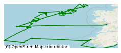
CE09014 Cetaceans on the Frontier Survey 2009 North East Atlantic Ocean
This survey, led by Galway-Mayo Institute of Technology (GMIT) and the Irish Whale and Dolphin Group (IWDG) was conducted on board the Marine Institute’s R.V. Celtic Explorer as a dedicated survey between 18th and 31st August 2009. The survey area covered waters over the Porcupine Bank, Porcupine Slopes and Irish Shelf and slopes to the west of Mayo. The survey track was designed to target deep-water canyons on the slopes of the Porcupine Bank and the Irish Northwest Shelf. The main aims of the survey were to carry out visual and acoustic surveys of cetaceans, visual bird and macrofauna surveys, the deployment of the M6 weather buoy and two Deep C-PODs for acoustic monitoring, The survey vessel travelled at an average speed of 8 knots while on transect, except in heavy swell. The ship spent from 08:30 – 18:30 each day on visual and acoustic transect, and from 20:30 – 08:30 altered between steaming at 8 knots and being stationary while conducting CTDs, water sampling and plankton hauls. Visual and acoustic surveys for cetaceans were conducted. A towed hydrophone array was used and two Deep C-PODs were deployed during the survey. One POD was deployed on a benthic mooring in 1500m of water, with the sensor facing upwards towards the surface.A second Deep C-POD was deployed at 500m water depth on the mooring for the M6 Weather Buoy. The buoy was moored in 3200m of water. The POD was deployed with the sensor facing down towards the seabed Acoustic data from bottlenose dolphin (Tursiops truncatus) encounters were recorded using passive acoustic techniques and provided to a PhD study (based in University College Cork and funded by IRCSET). Visual seabird surveys and megafauna surveys were also conducted on this cruise, as well as the deployment of an argo float. As the primary purpose of the cruise was to record the distribution of cetaceans using visual and acoustic techniques, oceanographic work was conducted only after sunset. 11 oceanographic stations were sampled. Zooplankton samples were not taken at every station due to time constraints (only stations 1, 2, 8, 9, 10, 11). CTD data however was collected at all stations The main focus of the survey was to conduct a habitat specific survey of deep diving cetaceans, particularly the enigmatic beaked whale species.
Simple
- Date (Publication)
- 2021-01-18
- Date (Revision)
- 2021-01-18
- Date (Creation)
- 2021-01-18
- Citation identifier
- ie.marine.data:dataset.4437
- Point of contact
-
Organisation name Individual name Electronic mail address Role Atlantic Technological University
Originator
- Maintenance and update frequency
- As needed
- Use limitation
-
While every effort is made in preparing the dataset no responsibility is accepted by or on behalf of the Marine Institute for any errors, omissions or misleading information. The Marine Institute accepts no responsibility for loss or damage occasioned or claimed to have been occasioned, in part or in full, as a consequence of any person acting, or refraining from acting as a result of a matter contained in this datasets or as a consequence of using this dataset for any purpose whatsoever.
- Use limitation
-
A Creative Commons (CC) license is one of several public copyright licenses that enable the free distribution of an otherwise copyrighted work. A CC license is used when an author wants to give people the right to share, use, and build upon a work that they have created. Under Creative Commons CC BY 4.0 the following is granted: Rights Share — copy and redistribute the material in any medium or format; Adapt — remix, transform, and build upon the material for any purpose, even commercially. The licensor cannot revoke these freedoms as long as you follow the license terms. Requirements Attribution — You must give appropriate credit, provide a link to the license, and indicate if changes were made. You may do so in any reasonable manner, but not in any way that suggests the licensor endorses you or your use. No additional restrictions — You may not apply legal terms or technological measures that legally restrict others from doing anything the license permits.
- Access constraints
- CC%20BY%204.0
- Aggregate Datasetindentifier
- ie.marine.data:platform.33
- Association Type
- Cross reference
- Initiative Type
- Platform
- Aggregate Datasetindentifier
- ie.marine.data:dataset.848
- Association Type
- Cross reference
- Initiative Type
- Collection
- Aggregate Datasetindentifier
- ie.marine.data:dataset.845
- Association Type
- Cross reference
- Initiative Type
- Collection
- Spatial representation type
- Grid
- Language
- English
- Begin date
- 2009-08-18
- End date
- 2009-08-31
))
- Reference system identifier
- INSPIRE RS registry / http://www.opengis.net/def/crs/EPSG/0/3857
- Distribution format
-
Name Version CSV CTD Data
CSV Underway Data
- OnLine resource
-
Protocol Linkage Name WWW:LINK-1.0-http--link
http://www.marine.ie
- Hierarchy level
- Dataset
Conformance result
- Title
-
Commission Regulation (EU) No 1089/2010 of 23 November 2010 implementing Directive 2007/2/EC of the European Parliament and of the Council as regards interoperability of spatial data sets and services
- Date (Publication)
- 2010-12-08
- Explanation
-
See the referenced specification
- Pass
- Yes
- Statement
-
Data supplied by Marine Institute.
Metadata
- File identifier
- ie.marine.data:dataset.4437 XML
- Metadata language
- English
- Hierarchy level
- Collection session
- Date stamp
- 2025-02-21T18:28:40.540514Z
- Metadata standard name
-
ISDI Metadata Profile
- Metadata standard version
-
1.2
- Metadata author
-
Organisation name Individual name Electronic mail address Role Marine Institute
Point of contact
)))
