 Irish Spatial Data Exchange
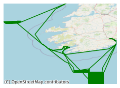
CV20020 INFOMAR Seabed Mapping Survey 2020 North East Atlantic Ocean
CV20020 INFOMAR seabed mapping survey took place in August/September 2020 in the North East Atlantic Ocean, off the coast of Ireland and in the Celtic Sea on board the RV Celtic Voyager. The aims of the survey were to . 1. Undertake a Multibeam Echo Sounder (MBES) hydrographic survey to International Hydrographic Organisation (IHO) Order 1A standard in depths less than 100 m and Order 2 in areas deeper than 100 m. 2. Produce bathymetry, shaded relief and backscatter mosaic products to provide depth, seabed features and seabed hardness/roughness information. 3. Acquire Sub Bottom Profiler (SBP) data of the shallow (up to 30 m) sub seabed to determine the existence of buried objects and ascertain the sub-seabed character. 4. Acquire magnetometer data to investigate the sub seabed geology and provide information on manmade seafloor debris. 5. Map in detail and provide hydrographic wreck reports on any wrecks. 6. Film a documentary for a TV programme titled Lighthouses of Ireland. INFOMAR is a Irish Department of Communications, Climate Action and the Environment (DCCAE) funded joint programme between the Geological Survey Ireland and the Marine Institute, surveying our unmapped marine territory and creating a range of integrated mapping products of the physical, chemical and biological features of the seabed.
Simple
- Date (Publication)
- 2020-10-22
- Date (Revision)
- 2020-10-22
- Date (Creation)
- 2020-10-22
- Citation identifier
- ie.marine.data:dataset.4419
- Point of contact
-
Organisation name Individual name Electronic mail address Role Marine Institute
Originator
- Maintenance and update frequency
- As needed
- Use limitation
-
While every effort is made in preparing the dataset no responsibility is accepted by or on behalf of the Marine Institute for any errors, omissions or misleading information. The Marine Institute accepts no responsibility for loss or damage occasioned or claimed to have been occasioned, in part or in full, as a consequence of any person acting, or refraining from acting as a result of a matter contained in this datasets or as a consequence of using this dataset for any purpose whatsoever.
- Use limitation
-
A Creative Commons (CC) license is one of several public copyright licenses that enable the free distribution of an otherwise copyrighted work. A CC license is used when an author wants to give people the right to share, use, and build upon a work that they have created. Under Creative Commons CC BY 4.0 the following is granted: Rights Share — copy and redistribute the material in any medium or format; Adapt — remix, transform, and build upon the material for any purpose, even commercially. The licensor cannot revoke these freedoms as long as you follow the license terms. Requirements Attribution — You must give appropriate credit, provide a link to the license, and indicate if changes were made. You may do so in any reasonable manner, but not in any way that suggests the licensor endorses you or your use. No additional restrictions — You may not apply legal terms or technological measures that legally restrict others from doing anything the license permits.
- Access constraints
- CC%20BY%204.0
- Aggregate Datasetindentifier
- ie.marine.data:platform.34
- Association Type
- Cross reference
- Initiative Type
- Platform
- Aggregate Datasetindentifier
- ie.marine.data:dataset.845
- Association Type
- Cross reference
- Initiative Type
- Collection
- Spatial representation type
- Vector
- Language
- English
- Begin date
- 1920-08-29
- End date
- 1920-09-22
))
- Reference system identifier
- INSPIRE RS registry / http://www.opengis.net/def/crs/EPSG/0/3857
- Distribution format
-
Name Version CSV Underway Data
- OnLine resource
-
Protocol Linkage Name WWW:LINK-1.0-http--link
http://www.infomar.ie/
- OnLine resource
-
Protocol Linkage Name WWW:LINK-1.0-http--link
http://www.marine.ie
- Hierarchy level
- Dataset
Conformance result
- Title
-
Commission Regulation (EU) No 1089/2010 of 23 November 2010 implementing Directive 2007/2/EC of the European Parliament and of the Council as regards interoperability of spatial data sets and services
- Date (Publication)
- 2010-12-08
- Explanation
-
See the referenced specification
- Pass
- Yes
- Statement
-
Data supplied by Marine Institute.
Metadata
- File identifier
- ie.marine.data:dataset.4419 XML
- Metadata language
- English
- Hierarchy level
- Collection session
- Date stamp
- 2025-02-21T18:28:42.994176Z
- Metadata standard name
-
ISDI Metadata Profile
- Metadata standard version
-
1.2
- Metadata author
-
Organisation name Individual name Electronic mail address Role Marine Institute
Point of contact
)))
