 Irish Spatial Data Exchange
CE20009 Constraining the Impact of Arctic Amplification in the Nordic Sea: A biogeochemical approach (CIAAN) Celtic Explorer 2020
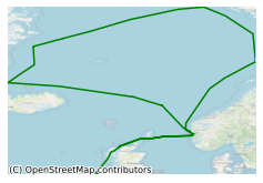
Cruise CIAAN (Constraining the Impact of Arctic Amplification in the Nordic Sea) was a 16 day interdisciplinary and multi-themed research cruise that took place on board the R.V. Celtic Explorer in August/September 2020, The cruise took a holistic approach to transform our understanding of how the signature of climate change is recorded in the Nordic Seas (e.g. temperature, salinity, and the carbonate system (CTD)) and transferred into geologic archives (Multi- and Gravity Cores) via foraminifera. The work program was multinational and facilitated trans-European co-operation through collaboration between an Irish and three leading European Institutes. It brought together researchers from two disciplines at the National University of Ireland Galway (NUIG) - Geography and Earth and Ocean Sciences, with researchers also from the University of Southampton, MARUM Research Facility in Germany and the Bjerknes Centre for Climate Research in Norway. During the survey 13 CTD , 11 Multinet Vertical and 7 Multinet Oblique casts were successfully carried out. 5 Multicores, 2 Box Corer and 12 gravity core casts were also conducted. 3 Argo floats were also deployed. The research linked to the project 'Constraining the Impact of Arctic Amplification in the Nordic Sea (CIAAN)' will support global efforts to improve our understanding of Essential Climate Variables (ECVs) in the Nordic Seas, which is a key region for the formation of North Atlantic Deepwater and the uptake of atmospheric carbon dioxide (pCO2). Specifically, CIAAN aims to define a more comprehensive description of biogeochemical processes in the Nordic Seas and will provide transformative insights into how ECVs are recorded in geologic archives to improve the “long-term monitoring, surveying and modelling to understand the processes and feedback mechanisms between the ocean and atmospheric systems” (Joint Programming Initiative Healthy and Productive Seas and Oceans).
Simple
- Date (Publication)
- 2020-10-01
- Date (Revision)
- 2021-02-03
- Date (Creation)
- 2020-10-01
- Citation identifier
- ie.marine.data:dataset.4400
- Point of contact
-
Organisation name Individual name Electronic mail address Role University of Galway
Originator
- Maintenance and update frequency
- As needed
- Use limitation
-
While every effort is made in preparing the dataset no responsibility is accepted by or on behalf of the Marine Institute for any errors, omissions or misleading information. The Marine Institute accepts no responsibility for loss or damage occasioned or claimed to have been occasioned, in part or in full, as a consequence of any person acting, or refraining from acting as a result of a matter contained in this datasets or as a consequence of using this dataset for any purpose whatsoever.
- Use limitation
-
A Creative Commons (CC) license is one of several public copyright licenses that enable the free distribution of an otherwise copyrighted work. A CC license is used when an author wants to give people the right to share, use, and build upon a work that they have created. Under Creative Commons CC BY 4.0 the following is granted: Rights Share — copy and redistribute the material in any medium or format; Adapt — remix, transform, and build upon the material for any purpose, even commercially. The licensor cannot revoke these freedoms as long as you follow the license terms. Requirements Attribution — You must give appropriate credit, provide a link to the license, and indicate if changes were made. You may do so in any reasonable manner, but not in any way that suggests the licensor endorses you or your use. No additional restrictions — You may not apply legal terms or technological measures that legally restrict others from doing anything the license permits.
- Access constraints
- CC%20BY%204.0
- Aggregate Datasetindentifier
- ie.marine.data:platform.33
- Association Type
- Cross reference
- Initiative Type
- Platform
- Aggregate Datasetindentifier
- ie.marine.data:dataset.848
- Association Type
- Cross reference
- Initiative Type
- Collection
- Aggregate Datasetindentifier
- ie.marine.data:dataset.845
- Association Type
- Cross reference
- Initiative Type
- Collection
- Spatial representation type
- Vector
- Language
- English
- Begin date
- 1920-08-24
- End date
- 1920-09-16
))
- Reference system identifier
- INSPIRE RS registry / http://www.opengis.net/def/crs/EPSG/0/3857
- Distribution format
-
Name Version CSV CTD Data
CSV Underway Data
- OnLine resource
-
Protocol Linkage Name WWW:LINK-1.0-http--link
http://www.marine.ie
- Hierarchy level
- Dataset
Conformance result
- Title
-
Commission Regulation (EU) No 1089/2010 of 23 November 2010 implementing Directive 2007/2/EC of the European Parliament and of the Council as regards interoperability of spatial data sets and services
- Date (Publication)
- 2010-12-08
- Explanation
-
See the referenced specification
- Pass
- Yes
- Statement
-
Data supplied by Marine Institute.
Metadata
- File identifier
- ie.marine.data:dataset.4400 XML
- Metadata language
- English
- Hierarchy level
- Collection session
- Date stamp
- 2025-02-21T18:28:46.324724Z
- Metadata standard name
-
ISDI Metadata Profile
- Metadata standard version
-
1.2
- Metadata author
-
Organisation name Individual name Electronic mail address Role Marine Institute
Point of contact
)))
