 Irish Spatial Data Exchange
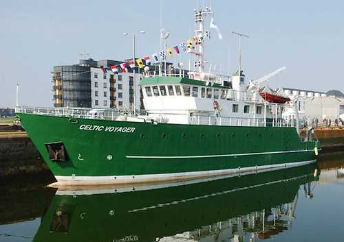
CV16037 INFOMAR (Seabed mapping) Trials Survey
The INtegrated Mapping FOr the Sustainable Development of Ireland’s MArine Resource (INFOMAR) programme is a joint venture between the Geological Survey of Ireland (GSI) and the Marine Institute (MI). The programme is a successor to the Irish National Seabed Survey (INSS) and concentrates on creating a range of integrated mapping products of the physical, chemical and biological features of the seabed in the near-shore area. This two day survey took place on board the R.V. Celtic Voyager in January 2016 in Cork Harbour to trial seabed mapping equipment. Tests on the multibeam echosounder, magnetometers and two Sound Velocity Profiles (SVPs) were carried out. Patch test EM2040. Install new Coda system and acquire data. Test magnetometers. test 2 x SVPs, network PCs.
Simple
- Date (Publication)
- 2018-01-25
- Date (Revision)
- 2018-11-29
- Date (Creation)
- 2018-01-25
- Citation identifier
- ie.marine.data:dataset.2135
- Point of contact
-
Organisation name Individual name Electronic mail address Role Marine Institute
Originator
- Maintenance and update frequency
- As needed
- Use limitation
-
While every effort is made in preparing the dataset no responsibility is accepted by or on behalf of the Marine Institute for any errors, omissions or misleading information. The Marine Institute accepts no responsibility for loss or damage occasioned or claimed to have been occasioned, in part or in full, as a consequence of any person acting, or refraining from acting as a result of a matter contained in this datasets or as a consequence of using this dataset for any purpose whatsoever.
- Aggregate Datasetindentifier
- ie.marine.data:platform.34
- Association Type
- Cross reference
- Initiative Type
- Platform
- Spatial representation type
- Grid
- Language
- English
- Begin date
- 2016-01-25
- End date
- 2016-01-26
))
- Reference system identifier
- INSPIRE RS registry / http://www.opengis.net/def/crs/EPSG/0/3857
- OnLine resource
-
Protocol Linkage Name WWW:LINK-1.0-http--link
http://www.infomar.ie/
- Hierarchy level
- Dataset
Conformance result
- Title
-
Commission Regulation (EU) No 1089/2010 of 23 November 2010 implementing Directive 2007/2/EC of the European Parliament and of the Council as regards interoperability of spatial data sets and services
- Date (Publication)
- 2010-12-08
- Explanation
-
See the referenced specification
- Pass
- Yes
- Statement
-
Data supplied by Marine Institute.
Metadata
- File identifier
- ie.marine.data:dataset.2135 XML
- Metadata language
- English
- Hierarchy level
- Collection session
- Date stamp
- 2025-02-21T18:23:40.02522Z
- Metadata standard name
-
ISDI Metadata Profile
- Metadata standard version
-
1.2
- Metadata author
-
Organisation name Individual name Electronic mail address Role Marine Institute
Point of contact
)))
