 Irish Spatial Data Exchange
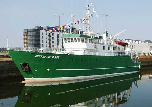
CV17021 Nephrops Underwater TV (UWTV) Celtic Sea Survey - Leg 2
Annual second leg underwater television (UWTV) survey of abundance and distribution of Nephrops in the Celtic Sea Nephrops Grounds. The prawn (Nephrops norvegicus) are common in the Celtic Sea occurring in geographically distinct sandy/muddy areas where the sediment is suitable for them to construct their burrows. The Celtic Sea area supports a large multi-national targeted Nephrops fishery mainly using otter trawls. This survey was carried out by the Marine Institute on board the R.V. Celtic Voyager in August 2017 in the Celtic Sea. A total of 40 UWTV stations were surveyed successfully (good quality video footage), carried out over an isometric grid at 4.5nmi or 8.3km intervals. Mean density was calculated by dividing the total number of burrow systems by the survey area observed. Ten beam trawl tows were conducted providing important data on the benthic communities and size structure of the Nephrops population. All Nephrops caught were sorted by sex and maturity category, weighed and measured using the NEMESYS electronic measuring system. The fish catch was identified to species level and sampled by weight (kgs) only. The benthic catch was identified and weighed (g) and counted. No Conductivity, Temperature and Depth (CTD) data was collected during this survey due to technical problems. 1. To complete randomised fixed isometric survey grid of 40 UWTV with 4.5 nautical mile (nmi) spacing stations on the “Smalls” Nephrops ground (FU22). 2. To obtain 2017 quality assured estimates of Nephrops burrow distribution and abundance on the "Smalls” Nephrops ground 3. To collect ancillary information from the UWTV footage collected at each station such as the occurrence of sea-pens, other macro benthos and fish species and trawl marks on the sea bed. 4. To sample Nephrops and macro benthos using a 4 m beam trawl deployed at ~10 stations.
Simple
- Date (Publication)
- 2018-01-15
- Date (Revision)
- 2023-06-01
- Date (Creation)
- 2018-01-15
- Citation identifier
- ie.marine.data:dataset.1939
- Point of contact
-
Organisation name Individual name Electronic mail address Role Marine Institute
Originator
- Maintenance and update frequency
- As needed
- SeaDataNet Parameter Discovery Vocabulary
-
- Vertical spatial coordinates
- Horizontal spatial co-ordinates
- Sea level
- Date and time
- SeaDataNet biological format biotic parameters
- Air pressure
- Air temperature
- Atmospheric humidity
- Electrical conductivity of the water column
- Wind strength and direction
- Platform or instrument orientation
- Salinity of the water column
- Density of the water column
- Temperature of the water column
- Use limitation
-
While every effort is made in preparing the dataset no responsibility is accepted by or on behalf of the Marine Institute for any errors, omissions or misleading information. The Marine Institute accepts no responsibility for loss or damage occasioned or claimed to have been occasioned, in part or in full, as a consequence of any person acting, or refraining from acting as a result of a matter contained in this datasets or as a consequence of using this dataset for any purpose whatsoever.
- Use limitation
-
A Creative Commons (CC) license is one of several public copyright licenses that enable the free distribution of an otherwise copyrighted work. A CC license is used when an author wants to give people the right to share, use, and build upon a work that they have created. Under Creative Commons CC BY 4.0 the following is granted: Rights Share — copy and redistribute the material in any medium or format; Adapt — remix, transform, and build upon the material for any purpose, even commercially. The licensor cannot revoke these freedoms as long as you follow the license terms. Requirements Attribution — You must give appropriate credit, provide a link to the license, and indicate if changes were made. You may do so in any reasonable manner, but not in any way that suggests the licensor endorses you or your use. No additional restrictions — You may not apply legal terms or technological measures that legally restrict others from doing anything the license permits.
- Access constraints
- CC%20BY%204.0
- Aggregate Datasetindentifier
- ie.marine.data:instrument.45
- Association Type
- Cross reference
- Initiative Type
- Sensor
- Aggregate Datasetindentifier
- ie.marine.data:instrument.195
- Association Type
- Cross reference
- Initiative Type
- Sensor
- Aggregate Datasetindentifier
- ie.marine.data:instrument.198
- Association Type
- Cross reference
- Initiative Type
- Sensor
- Aggregate Datasetindentifier
- ie.marine.data:instrument.199
- Association Type
- Cross reference
- Initiative Type
- Sensor
- Aggregate Datasetindentifier
- ie.marine.data:instrument.755
- Association Type
- Cross reference
- Initiative Type
- Sensor
- Aggregate Datasetindentifier
- ie.marine.data:instrument.756
- Association Type
- Cross reference
- Initiative Type
- Sensor
- Aggregate Datasetindentifier
- ie.marine.data:instrument.766
- Association Type
- Cross reference
- Initiative Type
- Sensor
- Aggregate Datasetindentifier
- ie.marine.data:instrument.771
- Association Type
- Cross reference
- Initiative Type
- Sensor
- Aggregate Datasetindentifier
- ie.marine.data:instrument.836
- Association Type
- Cross reference
- Initiative Type
- Sensor
- Aggregate Datasetindentifier
- ie.marine.data:instrument.1289
- Association Type
- Cross reference
- Initiative Type
- Sensor
- Aggregate Datasetindentifier
- ie.marine.data:instrument.2069
- Association Type
- Cross reference
- Initiative Type
- Sensor
- Aggregate Datasetindentifier
- ie.marine.data:platform.34
- Association Type
- Cross reference
- Initiative Type
- Platform
- Aggregate Datasetindentifier
- ie.marine.data:dataset.845
- Association Type
- Cross reference
- Initiative Type
- Collection
- Aggregate Datasetindentifier
- ie.marine.data:dataset.972
- Association Type
- Cross reference
- Initiative Type
- Collection
- Aggregate Datasetindentifier
- ie.marine.data:dataset.972
- Association Type
- Cross reference
- Initiative Type
- Collection
- Aggregate Datasetindentifier
- ie.marine.data:dataset.848
- Association Type
- Cross reference
- Initiative Type
- Collection
- Spatial representation type
- Grid
- Language
- English
- Begin date
- 2017-08-09
- End date
- 2017-08-18
))
- Reference system identifier
- INSPIRE RS registry / http://www.opengis.net/def/crs/EPSG/0/3857
- OnLine resource
-
Protocol Linkage Name WWW:LINK-1.0-http--link
http://www.marine.ie
- Hierarchy level
- Dataset
Conformance result
- Title
-
Commission Regulation (EU) No 1089/2010 of 23 November 2010 implementing Directive 2007/2/EC of the European Parliament and of the Council as regards interoperability of spatial data sets and services
- Date (Publication)
- 2010-12-08
- Explanation
-
See the referenced specification
- Pass
- Yes
- Statement
-
Data supplied by Marine Institute.
Metadata
- File identifier
- ie.marine.data:dataset.1939 XML
- Metadata language
- English
- Hierarchy level
- Collection session
- Date stamp
- 2025-02-21T18:23:14.647799Z
- Metadata standard name
-
ISDI Metadata Profile
- Metadata standard version
-
1.2
- Metadata author
-
Organisation name Individual name Electronic mail address Role Marine Institute
Point of contact
)))
