 Irish Spatial Data Exchange
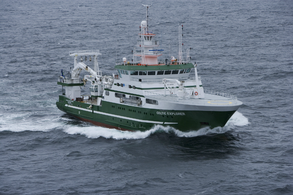
CE0608 Marine Aerosol Production (MAP) Survey
Primary marine aerosol production (MAP) is produced by the interaction between wind and waves. The wind drag at the sea surface creates waves. When the wind speeds exceeds a certain threshold, between 4 and 7 ms-1, the drag becomes so high that the waves break and air is entrained into the water. The air breaks up into bubbles which rise to the surface where they burst and produce sea spray aerosol. The sea spray source function (S3F) describes the sea spray flux per unit area and per unit of time, parameterized as function of environmental parameters such as wind speed and/or water temperature. One of the goals EU FP6 project MAP (Marine Aerosol Production) coordinated by the National University of Ireland, Galway (NUIG) is “to quantify the number and size flux of primary inorganic and organic marine sea-spray aerosol (PMA)”. Data to achieve this objective were collected during the MAP cruise on board the Marine Institute's R.V. Celtic Explorer in June-July 2006. Various types of experiments were conducted to provide data to derive the S3F. For whitecap measurements, a mast on the foredeck was constructed and mounted to measure sea spray fluxes using eddy covariance. Containers on the foredeck contained sophisticated instrumentation for characterisation of atmospheric components relevant for the assessment of primary and secondary aerosol production: atmospheric trace gases and aerosol chemical and physical properties. A whitecap camera was also mounted to the railing of the Monkey deck of the vessel. To quantify the number and size flux of primary inorganic and organic marine sea-spray aerosol (PMA)
Simple
- Date (Publication)
- 2018-01-10
- Date (Revision)
- 2018-11-29
- Date (Creation)
- 2018-01-10
- Citation identifier
- ie.marine.data:dataset.1863
- Point of contact
-
Organisation name Individual name Electronic mail address Role Marine Institute
Originator
- Maintenance and update frequency
- As needed
- Use limitation
-
While every effort is made in preparing the dataset no responsibility is accepted by or on behalf of the Marine Institute for any errors, omissions or misleading information. The Marine Institute accepts no responsibility for loss or damage occasioned or claimed to have been occasioned, in part or in full, as a consequence of any person acting, or refraining from acting as a result of a matter contained in this datasets or as a consequence of using this dataset for any purpose whatsoever.
- Use limitation
-
A Creative Commons (CC) license is one of several public copyright licenses that enable the free distribution of an otherwise copyrighted work. A CC license is used when an author wants to give people the right to share, use, and build upon a work that they have created. Under Creative Commons CC BY 4.0 the following is granted: Rights Share — copy and redistribute the material in any medium or format; Adapt — remix, transform, and build upon the material for any purpose, even commercially. The licensor cannot revoke these freedoms as long as you follow the license terms. Requirements Attribution — You must give appropriate credit, provide a link to the license, and indicate if changes were made. You may do so in any reasonable manner, but not in any way that suggests the licensor endorses you or your use. No additional restrictions — You may not apply legal terms or technological measures that legally restrict others from doing anything the license permits.
- Access constraints
- CC%20BY%204.0
- Aggregate Datasetindentifier
- ie.marine.data:instrument.45
- Association Type
- Cross reference
- Initiative Type
- Sensor
- Aggregate Datasetindentifier
- ie.marine.data:instrument.195
- Association Type
- Cross reference
- Initiative Type
- Sensor
- Aggregate Datasetindentifier
- ie.marine.data:instrument.198
- Association Type
- Cross reference
- Initiative Type
- Sensor
- Aggregate Datasetindentifier
- ie.marine.data:instrument.199
- Association Type
- Cross reference
- Initiative Type
- Sensor
- Aggregate Datasetindentifier
- ie.marine.data:platform.33
- Association Type
- Cross reference
- Initiative Type
- Platform
- Aggregate Datasetindentifier
- ie.marine.data:dataset.845
- Association Type
- Cross reference
- Initiative Type
- Collection
- Aggregate Datasetindentifier
- ie.marine.data:dataset.848
- Association Type
- Cross reference
- Initiative Type
- Collection
- Spatial representation type
- Grid
- Language
- English
- Begin date
- 2006-06-07
- End date
- 2006-07-07
))
- Reference system identifier
- INSPIRE RS registry / http://www.opengis.net/def/crs/EPSG/0/3857
- Distribution format
-
Name Version CSV CTD Data
CSV Underway Data
- OnLine resource
-
Protocol Linkage Name WWW:LINK-1.0-http--link
http://www.marine.ie
- OnLine resource
-
Protocol Linkage Name WWW:LINK-1.0-http--link
http://www.seadatanet.org/
- Hierarchy level
- Dataset
Conformance result
- Title
-
Commission Regulation (EU) No 1089/2010 of 23 November 2010 implementing Directive 2007/2/EC of the European Parliament and of the Council as regards interoperability of spatial data sets and services
- Date (Publication)
- 2010-12-08
- Explanation
-
See the referenced specification
- Pass
- Yes
- Statement
-
Data supplied by Marine Institute.
Metadata
- File identifier
- ie.marine.data:dataset.1863 XML
- Metadata language
- English
- Hierarchy level
- Collection session
- Date stamp
- 2025-02-21T18:23:26.052937Z
- Metadata standard name
-
ISDI Metadata Profile
- Metadata standard version
-
1.2
- Metadata author
-
Organisation name Individual name Electronic mail address Role Marine Institute
Point of contact
)))
