 Irish Spatial Data Exchange
CE0810 (MeBo2008) Integrated National Strategic Deep-Water Seabed Drilling Campaign (INS DeepDrill)
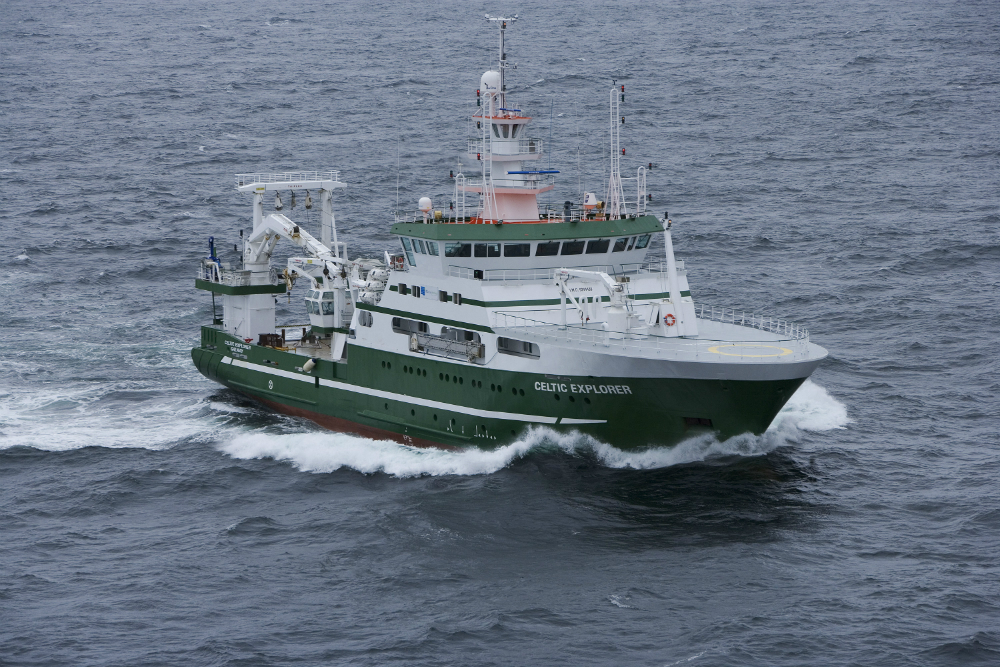
INS DeepDrill targets Ireland’s national strategic needs for deep-water seabed drilling and full core recovery at intermediate seabed penetration (down to 70m). This is accomplished through the mobilisation of the advanced portable seafloor drilling rig MeBo financially facilitated through the European Science Foundation EuroCORES - EuroMARC CARBONATE seabed drilling programme and the Irish Shelf Porcupine Studies Group (ISPSG) of the Petroleum Infrastructure Programme (PIP) – Ireland's joint Government-Industry research programme, which comprises hydrocarbon exploration companies active in offshore Ireland and the Petroleum Affairs Division (PAD) of the Department of Communications, Energy and Natural Resources. The key objective of the expedition was to cost-effectively collect fullrecovery core sequences in lithified substrates in support of the ESF-CARBONATE programme and ISPSG Rock Drilling program. Along the European Atlantic continental margin, cold-water corals and coldwater coral carbonate mounds occur from northern Norway to the Gulf of Cádiz. The mounds differ considerably in size (5-380 m) and present day ‘activity’ (covered with abundant living corals at the SW Rockall Trough margin to fully buried mounds in the Porcupine Seabight). Up to now the carbonate stored in these mounds has not been considered in the global carbon budget. A challenge existed to quantify the amount and flux of carbon stored in these structures. Previous investigations of short sediment cores revealed that all mounds possess different growth histories depending on the environmental setting and the involved faunal associations. These previous cores penetrated only the upper few metres of the mounds thus limiting the research to the very late stage of mound development. By understanding how biogeochemical processes control the development of these carbonate mounds and their response to climate change, CARBONATE (Mid latitude carbonate systems: complete sequences from cold-water coral carbonate mounds in the northeast Atlantic) aims at quantifying their role as mid-latitude carbonate sinks. The main aim of the CARBONATE and INS DeepDrill was to drill through several mounds (in total six carbonate mound locations in Porcupine-Rockall area at various locations in order to understand the role of the environmental parameters on mound formation and the role of the mounds in the global carbon cycle. This 23 day survey took place on board the Marine Institute's R.V. Celtic Explorer from 15th of August after 4.5 days of mobilisation of MeBo in Galway, Ireland, and ended there again on the 6th of September 2008 followed by 2 day of de-mobilisation of MeBo. In addition to the drills and ground truthing conducted, CTD (Conductivity, Temperature and Depth) casts were deployed to measure variations in salinity, temperature and dissolved oxygen in the water column as well as to take water samples. The main aim of the CARBONATE and INS DeepDrill was to drill through several mounds (in total six carbonate mound locations in Porcupine-Rockall area at various locations in order to understand the role of the environmental parameters on mound formation and the role of the mounds in the global carbon cycle.
Simple
- Date (Publication)
- 2018-01-09
- Date (Revision)
- 2018-11-29
- Date (Creation)
- 2018-01-09
- Citation identifier
- ie.marine.data:dataset.1820
- Point of contact
-
Organisation name Individual name Electronic mail address Role Marine Institute
Originator
- Maintenance and update frequency
- As needed
- Use limitation
-
While every effort is made in preparing the dataset no responsibility is accepted by or on behalf of the Marine Institute for any errors, omissions or misleading information. The Marine Institute accepts no responsibility for loss or damage occasioned or claimed to have been occasioned, in part or in full, as a consequence of any person acting, or refraining from acting as a result of a matter contained in this datasets or as a consequence of using this dataset for any purpose whatsoever.
- Use limitation
-
A Creative Commons (CC) license is one of several public copyright licenses that enable the free distribution of an otherwise copyrighted work. A CC license is used when an author wants to give people the right to share, use, and build upon a work that they have created. Under Creative Commons CC BY 4.0 the following is granted: Rights Share — copy and redistribute the material in any medium or format; Adapt — remix, transform, and build upon the material for any purpose, even commercially. The licensor cannot revoke these freedoms as long as you follow the license terms. Requirements Attribution — You must give appropriate credit, provide a link to the license, and indicate if changes were made. You may do so in any reasonable manner, but not in any way that suggests the licensor endorses you or your use. No additional restrictions — You may not apply legal terms or technological measures that legally restrict others from doing anything the license permits.
- Access constraints
- CC%20BY%204.0
- Aggregate Datasetindentifier
- ie.marine.data:instrument.45
- Association Type
- Cross reference
- Initiative Type
- Sensor
- Aggregate Datasetindentifier
- ie.marine.data:instrument.195
- Association Type
- Cross reference
- Initiative Type
- Sensor
- Aggregate Datasetindentifier
- ie.marine.data:instrument.198
- Association Type
- Cross reference
- Initiative Type
- Sensor
- Aggregate Datasetindentifier
- ie.marine.data:instrument.199
- Association Type
- Cross reference
- Initiative Type
- Sensor
- Aggregate Datasetindentifier
- ie.marine.data:platform.33
- Association Type
- Cross reference
- Initiative Type
- Platform
- Aggregate Datasetindentifier
- ie.marine.data:dataset.845
- Association Type
- Cross reference
- Initiative Type
- Collection
- Spatial representation type
- Grid
- Language
- English
- Begin date
- 2008-08-11
- End date
- 2008-09-08
))
- Reference system identifier
- INSPIRE RS registry / http://www.opengis.net/def/crs/EPSG/0/3857
- Distribution format
-
Name Version CSV Underway Data
- OnLine resource
-
Protocol Linkage Name WWW:LINK-1.0-http--link
http://www.marine.ie
- OnLine resource
-
Protocol Linkage Name WWW:LINK-1.0-http--link
http://www.seadatanet.org/
- Hierarchy level
- Dataset
Conformance result
- Title
-
Commission Regulation (EU) No 1089/2010 of 23 November 2010 implementing Directive 2007/2/EC of the European Parliament and of the Council as regards interoperability of spatial data sets and services
- Date (Publication)
- 2010-12-08
- Explanation
-
See the referenced specification
- Pass
- Yes
- Statement
-
Data supplied by Marine Institute.
Metadata
- File identifier
- ie.marine.data:dataset.1820 XML
- Metadata language
- English
- Hierarchy level
- Collection session
- Date stamp
- 2025-02-21T18:23:35.933483Z
- Metadata standard name
-
ISDI Metadata Profile
- Metadata standard version
-
1.2
- Metadata author
-
Organisation name Individual name Electronic mail address Role Marine Institute
Point of contact
)))
