 Irish Spatial Data Exchange
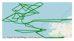
CE10008 Glacial and non-glacial sediment transport in the Rockall Trough and Porcupine Bank (North Atlantic Ocean)
Submarine landslides are the dominant sediment transport mechanism on continental margins, transferring volumes in the order of tens to hundreds of cubic kilometres from the continental slope to as far as the deep abyssal plain. Submarine landslides are known to be capable of destroying marine infrastructure such as submarine telecommunication cables and oil platform installations. The Rockall Trough and its margins, a relatively lightly-studied area, form a valuable natural laboratory holding information on slope stability, sediment transport, bottom ocean currents, and ice-sheet history. The primary aim of this cruise will be to intensively core a small basin on the southeast margin of the RT, with the intention of determining the frequency of slope instability on the opposite margin and aid assessment of potential tsunami hazards and characterising deep-water gravity flow processes and deposits in a narrow basin and the effect this has on flow transformation processes. This survey, led by University College Dublin (UCD), took place in June 2010 on board the Marine Institute's R.V. Celtic Explorer. The primary aim of this cruise was to intensively core a small basin on the southeast margin of the RT, with the intention of determining the frequency of slope instability on the opposite margin and aid assessment of potential tsunami hazards and characterising deep-water gravity flow processes and deposits in a narrow basin and the effect this has on flow transformation processes. Piston corers and Vibrocores were completed during the survey. The objectives of the survey to 1) study submarine landslide deposits and especially their timing, frequency and flow processes and 2) study the nature of continental margin sedimentation during both glacial- and non-glacial periods in the relatively unknown northern part of the Porcupine Bank.
Simple
- Date (Publication)
- 2018-01-08
- Date (Revision)
- 2018-11-29
- Date (Creation)
- 2018-01-08
- Citation identifier
- ie.marine.data:dataset.1766
- Point of contact
-
Organisation name Individual name Electronic mail address Role Marine Institute
Originator
- Maintenance and update frequency
- As needed
- Use limitation
-
While every effort is made in preparing the dataset no responsibility is accepted by or on behalf of the Marine Institute for any errors, omissions or misleading information. The Marine Institute accepts no responsibility for loss or damage occasioned or claimed to have been occasioned, in part or in full, as a consequence of any person acting, or refraining from acting as a result of a matter contained in this datasets or as a consequence of using this dataset for any purpose whatsoever.
- Use limitation
-
A Creative Commons (CC) license is one of several public copyright licenses that enable the free distribution of an otherwise copyrighted work. A CC license is used when an author wants to give people the right to share, use, and build upon a work that they have created. Under Creative Commons CC BY 4.0 the following is granted: Rights Share — copy and redistribute the material in any medium or format; Adapt — remix, transform, and build upon the material for any purpose, even commercially. The licensor cannot revoke these freedoms as long as you follow the license terms. Requirements Attribution — You must give appropriate credit, provide a link to the license, and indicate if changes were made. You may do so in any reasonable manner, but not in any way that suggests the licensor endorses you or your use. No additional restrictions — You may not apply legal terms or technological measures that legally restrict others from doing anything the license permits.
- Access constraints
- CC%20BY%204.0
- Aggregate Datasetindentifier
- ie.marine.data:instrument.45
- Association Type
- Cross reference
- Initiative Type
- Sensor
- Aggregate Datasetindentifier
- ie.marine.data:instrument.195
- Association Type
- Cross reference
- Initiative Type
- Sensor
- Aggregate Datasetindentifier
- ie.marine.data:instrument.198
- Association Type
- Cross reference
- Initiative Type
- Sensor
- Aggregate Datasetindentifier
- ie.marine.data:instrument.199
- Association Type
- Cross reference
- Initiative Type
- Sensor
- Aggregate Datasetindentifier
- ie.marine.data:platform.33
- Association Type
- Cross reference
- Initiative Type
- Platform
- Aggregate Datasetindentifier
- ie.marine.data:dataset.845
- Association Type
- Cross reference
- Initiative Type
- Collection
- Spatial representation type
- Grid
- Language
- English
- Begin date
- 2010-06-03
- End date
- 2010-06-17
))
- Reference system identifier
- INSPIRE RS registry / http://www.opengis.net/def/crs/EPSG/0/3857
- Distribution format
-
Name Version CSV Underway Data
- OnLine resource
-
Protocol Linkage Name WWW:LINK-1.0-http--link
http://www.marine.ie
- OnLine resource
-
Protocol Linkage Name WWW:LINK-1.0-http--link
http://www.seadatanet.org/
- Hierarchy level
- Dataset
Conformance result
- Title
-
Commission Regulation (EU) No 1089/2010 of 23 November 2010 implementing Directive 2007/2/EC of the European Parliament and of the Council as regards interoperability of spatial data sets and services
- Date (Publication)
- 2010-12-08
- Explanation
-
See the referenced specification
- Pass
- Yes
- Statement
-
Data supplied by Marine Institute.
Metadata
- File identifier
- ie.marine.data:dataset.1766 XML
- Metadata language
- English
- Hierarchy level
- Collection session
- Date stamp
- 2025-02-21T18:14:56.705975Z
- Metadata standard name
-
ISDI Metadata Profile
- Metadata standard version
-
1.2
- Metadata author
-
Organisation name Individual name Electronic mail address Role Marine Institute
Point of contact
)))
