 Irish Spatial Data Exchange
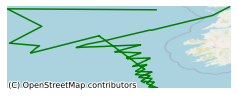
CE14020 Cetaceans on the Frontier 6 Survey
CTD and plankton sampling over the track covered during daylight hours, possible of moorings if weather forces (not ideal). Marine mammals monitoring survey. The overall objective of this cruise and the associated research is to collect data on the distribution and abundance of key marine mammals and seabirds within the Porcupine Basin and adjacent offshore areas. A range of different methodologies will be used to collect qualitative and quantative data. The primary objectives are; 1. To recover deployed moored passive acoustic arrays that were deployed in May 2014. These arrays will be used to assess anthropogenic and ambient sound data, and to detect marine mammal vocalisations in the Porcupine Basin and adjacent areas (See Appendix 1, Figure 2). High Priority. 2. To conduct double platform, absolute abundance survey of cetaceans in key habitats on the slopes and canyon systems of the Porcupine Basin (see Appendix 1, Figure 1) High Priority. 3. To conduct a habitat-focused, acoustic survey of cetacean distribution and relative abundance in key habitats all species using both low and high frequency acquisition systems (two towed hydrophone arrays) in the Porcupine Basin. Medium Priority. 4. To conduct a survey of seabird species and abundance according to European Seabirds at Sea (ESAS) methods in offshore waters over slope habitats of the Porcupine Bank, Sea Bight and shelf edge. High Priority. 5. To carry out systematic CTD sampling stations in order to explore relationships oceanographic variables and marine mammal abundances along the continental shelf habitat. Medium Priority. 6. Where possible, collect photo-identification data of bottlenose dolphins and baleen whales to facilitate on-going longitudinal studies (e.g. IWDG photo ID catalogue). Medium Priority.
Simple
- Date (Publication)
- 2018-01-03
- Date (Revision)
- 2018-11-29
- Date (Creation)
- 2018-01-03
- Citation identifier
- ie.marine.data:dataset.1645
- Point of contact
-
Organisation name Individual name Electronic mail address Role Marine Institute
Originator
- Maintenance and update frequency
- As needed
- Use limitation
-
While every effort is made in preparing the dataset no responsibility is accepted by or on behalf of the Marine Institute for any errors, omissions or misleading information. The Marine Institute accepts no responsibility for loss or damage occasioned or claimed to have been occasioned, in part or in full, as a consequence of any person acting, or refraining from acting as a result of a matter contained in this datasets or as a consequence of using this dataset for any purpose whatsoever.
- Use limitation
-
A Creative Commons (CC) license is one of several public copyright licenses that enable the free distribution of an otherwise copyrighted work. A CC license is used when an author wants to give people the right to share, use, and build upon a work that they have created. Under Creative Commons CC BY 4.0 the following is granted: Rights Share — copy and redistribute the material in any medium or format; Adapt — remix, transform, and build upon the material for any purpose, even commercially. The licensor cannot revoke these freedoms as long as you follow the license terms. Requirements Attribution — You must give appropriate credit, provide a link to the license, and indicate if changes were made. You may do so in any reasonable manner, but not in any way that suggests the licensor endorses you or your use. No additional restrictions — You may not apply legal terms or technological measures that legally restrict others from doing anything the license permits.
- Access constraints
- CC%20BY%204.0
- Aggregate Datasetindentifier
- ie.marine.data:instrument.45
- Association Type
- Cross reference
- Initiative Type
- Sensor
- Aggregate Datasetindentifier
- ie.marine.data:instrument.195
- Association Type
- Cross reference
- Initiative Type
- Sensor
- Aggregate Datasetindentifier
- ie.marine.data:instrument.198
- Association Type
- Cross reference
- Initiative Type
- Sensor
- Aggregate Datasetindentifier
- ie.marine.data:instrument.199
- Association Type
- Cross reference
- Initiative Type
- Sensor
- Aggregate Datasetindentifier
- ie.marine.data:platform.33
- Association Type
- Cross reference
- Initiative Type
- Platform
- Aggregate Datasetindentifier
- ie.marine.data:dataset.845
- Association Type
- Cross reference
- Initiative Type
- Collection
- Spatial representation type
- Grid
- Language
- English
- Begin date
- 2014-09-16
- End date
- 2014-09-23
))
- Reference system identifier
- INSPIRE RS registry / http://www.opengis.net/def/crs/EPSG/0/3857
- Distribution format
-
Name Version CSV Underway Data
- OnLine resource
-
Protocol Linkage Name WWW:LINK-1.0-http--link
http://www.marine.ie
- OnLine resource
-
Protocol Linkage Name WWW:LINK-1.0-http--link
http://www.seadatanet.org/
- Hierarchy level
- Dataset
Conformance result
- Title
-
Commission Regulation (EU) No 1089/2010 of 23 November 2010 implementing Directive 2007/2/EC of the European Parliament and of the Council as regards interoperability of spatial data sets and services
- Date (Publication)
- 2010-12-08
- Explanation
-
See the referenced specification
- Pass
- Yes
- Statement
-
Data supplied by Marine Institute.
Metadata
- File identifier
- ie.marine.data:dataset.1645 XML
- Metadata language
- English
- Hierarchy level
- Collection session
- Date stamp
- 2025-02-21T18:14:36.437301Z
- Metadata standard name
-
ISDI Metadata Profile
- Metadata standard version
-
1.2
- Metadata author
-
Organisation name Individual name Electronic mail address Role Marine Institute
Point of contact
)))
