 Irish Spatial Data Exchange
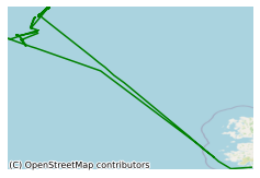
CE14011 Slope Collapses on Rockall Bank and Escarpment Habitats (SORBEH) Survey
This survey, led by University College Dublin (UCD), took place in July 2014 on board the Marine Institute's R.V. Celtic Explorer in the North East Atlantic Ocean. Originally there had been three objectives for SORBEH; 1) Lithological characterisation of the Eastern Rockall Bank by sampling areas in and around the Rockall Bank Slide Complex. 2) Habitat investigation of steep escarpments and seabed pinnacles using the Holland I ROV (Remotely Operated Vehicle). 3) Make measurements of wave-induced seafloor microseisms using a bespoke sensor array deployed on the way out and retrieved on the way in after 10 days. The third objective was not undertaken. A total of 12 core sites had been planned with two cores intended to be collected from every location. Six ROV dive sites had been targeted for video imaging and five of them for multibeam mapping. The Holland I performed 13 dives. In total conducting and obtaining video footage, still photographs, multibeam mapping, biological sampling, push cores and rock samples. The survey was conducted to 1) carry out Lithological characterisation of the Eastern Rockall Bank by sampling areas in and around the Rockall Bank Slide Complex. 2) Habitat investigation of steep escarpments and seabed pinnacles using the Holland I ROV.
Simple
- Date (Publication)
- 2018-01-03
- Date (Revision)
- 2018-11-29
- Date (Creation)
- 2018-01-03
- Citation identifier
- ie.marine.data:dataset.1631
- Point of contact
-
Organisation name Individual name Electronic mail address Role Marine Institute
Originator
- Maintenance and update frequency
- As needed
- Use limitation
-
While every effort is made in preparing the dataset no responsibility is accepted by or on behalf of the Marine Institute for any errors, omissions or misleading information. The Marine Institute accepts no responsibility for loss or damage occasioned or claimed to have been occasioned, in part or in full, as a consequence of any person acting, or refraining from acting as a result of a matter contained in this datasets or as a consequence of using this dataset for any purpose whatsoever.
- Use limitation
-
A Creative Commons (CC) license is one of several public copyright licenses that enable the free distribution of an otherwise copyrighted work. A CC license is used when an author wants to give people the right to share, use, and build upon a work that they have created. Under Creative Commons CC BY 4.0 the following is granted: Rights Share — copy and redistribute the material in any medium or format; Adapt — remix, transform, and build upon the material for any purpose, even commercially. The licensor cannot revoke these freedoms as long as you follow the license terms. Requirements Attribution — You must give appropriate credit, provide a link to the license, and indicate if changes were made. You may do so in any reasonable manner, but not in any way that suggests the licensor endorses you or your use. No additional restrictions — You may not apply legal terms or technological measures that legally restrict others from doing anything the license permits.
- Access constraints
- CC%20BY%204.0
- Aggregate Datasetindentifier
- ie.marine.data:instrument.45
- Association Type
- Cross reference
- Initiative Type
- Sensor
- Aggregate Datasetindentifier
- ie.marine.data:instrument.195
- Association Type
- Cross reference
- Initiative Type
- Sensor
- Aggregate Datasetindentifier
- ie.marine.data:instrument.198
- Association Type
- Cross reference
- Initiative Type
- Sensor
- Aggregate Datasetindentifier
- ie.marine.data:instrument.199
- Association Type
- Cross reference
- Initiative Type
- Sensor
- Aggregate Datasetindentifier
- ie.marine.data:platform.33
- Association Type
- Cross reference
- Initiative Type
- Platform
- Aggregate Datasetindentifier
- ie.marine.data:dataset.845
- Association Type
- Cross reference
- Initiative Type
- Collection
- Spatial representation type
- Grid
- Language
- English
- Begin date
- 2014-07-13
- End date
- 2014-07-27
))
- Reference system identifier
- INSPIRE RS registry / http://www.opengis.net/def/crs/EPSG/0/3857
- Distribution format
-
Name Version CSV Underway Data
- OnLine resource
-
Protocol Linkage Name WWW:LINK-1.0-http--link
http://www.marine.ie
- OnLine resource
-
Protocol Linkage Name WWW:LINK-1.0-http--link
http://www.seadatanet.org/
- Hierarchy level
- Dataset
Conformance result
- Title
-
Commission Regulation (EU) No 1089/2010 of 23 November 2010 implementing Directive 2007/2/EC of the European Parliament and of the Council as regards interoperability of spatial data sets and services
- Date (Publication)
- 2010-12-08
- Explanation
-
See the referenced specification
- Pass
- Yes
- Statement
-
Data supplied by Marine Institute.
Metadata
- File identifier
- ie.marine.data:dataset.1631 XML
- Metadata language
- English
- Hierarchy level
- Collection session
- Date stamp
- 2025-02-21T18:14:38.041943Z
- Metadata standard name
-
ISDI Metadata Profile
- Metadata standard version
-
1.2
- Metadata author
-
Organisation name Individual name Electronic mail address Role Marine Institute
Point of contact
)))
