 Irish Spatial Data Exchange
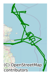
CE14001 Celtic Explorer Developing Geotechno Stratigraphies Survey (Leg2) Irish Sea 2014
This eight day survey (leg 2), led by University College Cork (UCC) took place on board R.V. Celtic Explorer in the North West and central Irish Sea in January 2014. Leg1 (CE13003) concentrated on North West Celtic Sea and offshore Dungarvan- the Saltees, collecting cores and seismic data for palaeoenvironmental and geotechnical studies. The overall objective of the surveys was to understand the control of palaeoenvironments on sedimentary sequence development and how, in turn, this controls geotechnical sub-seabed properties. The purpose of this survey was to perform in situ Cone Penetration Testing (CPTu) in order to groundtruth previously collected seismic data and obtain geotechnical data regarding the nature of sediment at depth. This involved a collaborative effort undertaken by University College Cork, MARUM (University of Bremen), the Marine Institute and Gaelectric Developments Ltd. The main area of focus was the north-western Mudbelt area of the Irish Sea; a large area earmarked for offshore renewable energy development. The Lambay Deep area was also the subject of a seismic survey to identify buried tunnel valleys and one site for CPT deployment. Under a 24 hour work routine, 17 sites were surveyed using the MARUM designed and built Geotechnical Offshore Survey Tool (GOST). In total some 306.17 m of good, in situ sub-seabed geotechnical data was collected. A Marine Mammal Observer was also on board to conduct visual surveys for cetaceans. The key objectives of the proposal are: (1) to determine the sub-seabed stratigraphy (the succession of sedimentary layers below the seabed) in high probability areas for renewable energy farm development (2) to obtain physical samples from the sub-seabed for geotechnical analysis (3) to obtain and analyse physical samples from the sub-seabed to determine the palaeo-environmental development of the seabed and submerged coastline and low-lying terrestrial areas through time (4) to map the spatial distribution and morphological characteristics of sedimentary bedforms and collect physical samples to advance our understanding of seabed mobility in key areas and to advise the industry on optimised cable emplacement strategy in target areas (5) to provide this data as (a) base-line data to both government bodies and industry for both site selection and future environmental assessment, and (b) key data to allow for realistic financial modelling for cost-effective installations and maintenance of offshore renewable energy farms.
Simple
- Date (Publication)
- 2018-01-03
- Date (Revision)
- 2021-02-25
- Date (Creation)
- 2018-01-03
- Citation identifier
- ie.marine.data:dataset.1617
- Point of contact
-
Organisation name Individual name Electronic mail address Role University College Cork
None
Originator
- Maintenance and update frequency
- As needed
- Use limitation
-
While every effort is made in preparing the dataset no responsibility is accepted by or on behalf of the Marine Institute for any errors, omissions or misleading information. The Marine Institute accepts no responsibility for loss or damage occasioned or claimed to have been occasioned, in part or in full, as a consequence of any person acting, or refraining from acting as a result of a matter contained in this datasets or as a consequence of using this dataset for any purpose whatsoever.
- Use limitation
-
A Creative Commons (CC) license is one of several public copyright licenses that enable the free distribution of an otherwise copyrighted work. A CC license is used when an author wants to give people the right to share, use, and build upon a work that they have created. Under Creative Commons CC BY 4.0 the following is granted: Rights Share — copy and redistribute the material in any medium or format; Adapt — remix, transform, and build upon the material for any purpose, even commercially. The licensor cannot revoke these freedoms as long as you follow the license terms. Requirements Attribution — You must give appropriate credit, provide a link to the license, and indicate if changes were made. You may do so in any reasonable manner, but not in any way that suggests the licensor endorses you or your use. No additional restrictions — You may not apply legal terms or technological measures that legally restrict others from doing anything the license permits.
- Access constraints
- CC%20BY%204.0
- Aggregate Datasetindentifier
- ie.marine.data:instrument.45
- Association Type
- Cross reference
- Initiative Type
- Sensor
- Aggregate Datasetindentifier
- ie.marine.data:instrument.195
- Association Type
- Cross reference
- Initiative Type
- Sensor
- Aggregate Datasetindentifier
- ie.marine.data:instrument.198
- Association Type
- Cross reference
- Initiative Type
- Sensor
- Aggregate Datasetindentifier
- ie.marine.data:instrument.199
- Association Type
- Cross reference
- Initiative Type
- Sensor
- Aggregate Datasetindentifier
- ie.marine.data:platform.33
- Association Type
- Cross reference
- Initiative Type
- Platform
- Aggregate Datasetindentifier
- ie.marine.data:dataset.845
- Association Type
- Cross reference
- Initiative Type
- Collection
- Spatial representation type
- Grid
- Language
- English
- Begin date
- 2014-01-10
- End date
- 2014-01-17
))
- Reference system identifier
- INSPIRE RS registry / http://www.opengis.net/def/crs/EPSG/0/3857
- Distribution format
-
Name Version CSV Underway Data
- OnLine resource
-
Protocol Linkage Name WWW:LINK-1.0-http--link
http://www.marine.ie
- OnLine resource
-
Protocol Linkage Name WWW:LINK-1.0-http--link
http://www.seadatanet.org/
- Hierarchy level
- Dataset
Conformance result
- Title
-
Commission Regulation (EU) No 1089/2010 of 23 November 2010 implementing Directive 2007/2/EC of the European Parliament and of the Council as regards interoperability of spatial data sets and services
- Date (Publication)
- 2010-12-08
- Explanation
-
See the referenced specification
- Pass
- Yes
- Statement
-
Data supplied by Marine Institute.
Metadata
- File identifier
- ie.marine.data:dataset.1617 XML
- Metadata language
- English
- Hierarchy level
- Collection session
- Date stamp
- 2025-02-21T18:14:42.714481Z
- Metadata standard name
-
ISDI Metadata Profile
- Metadata standard version
-
1.2
- Metadata author
-
Organisation name Individual name Electronic mail address Role Marine Institute
Point of contact
)))
