 Irish Spatial Data Exchange
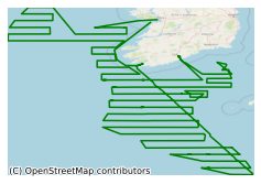
CE17009 The Western European Shelf Pelagic Acoustic Survey (WESPAS) Acoustic Survey Leg 1
The Western European Shelf Pelagic Acoustic Survey (WESPAS) survey program is the consolidation of two existing survey programs carried out by Fisheries Ecosystems Advisory Service (FEAS) in the Marine Institute. The Main Shelf herring acoustic survey has been carried out annually since 2008 and reports on the annual abundance of summer feeding aggregations of herring to the west of Scotland and north of Ireland. The boarfish survey has been carried out since 2011 using a chartered fishing vessel and reports on the abundance of spawning aggregations of boarfish 47N to 57N. In 2016 both surveys were combined providing synoptic coverage of shelf waters from 59N southwards to 47N. The 2017 survey took place over 2 legs; leg one (this cruise) was from 6th - 29th June, and leg 2 from 4th - 21 July 2017 on board the R.V. Celtic Explorer. Age stratified relative stock abundance estimates of boarfish, herring and horse mackerel within the survey area were calculated using acoustic data and biological data from trawl sampling. Conductivity, Temperature and Depth (CTD) data was aquired at predetermined stations. Zooplankton sampling was carried out alongside CTD stations. Marine mammal and seabird visual surveys were also conducted. Part of an annual survey to carry out acoustic surveys and biological sampling to calculate age stratified relative stock abundance estimates of boarfish, herring and horse mackerel within the survey. Stock estimates of boarfish and horse mackerel are then submitted to the ICES assessment Working Group for Widely Distributed Stocks (WGWIDE). Other objectives include collecting physical oceanography (CTD) data and visual surveys for marine mammals and seabirds.
Simple
- Date (Publication)
- 2017-12-20
- Date (Revision)
- 2018-11-29
- Date (Creation)
- 2017-12-20
- Citation identifier
- ie.marine.data:dataset.1503
- Point of contact
-
Organisation name Individual name Electronic mail address Role Marine Institute
Originator
- Maintenance and update frequency
- As needed
- Use limitation
-
While every effort is made in preparing the dataset no responsibility is accepted by or on behalf of the Marine Institute for any errors, omissions or misleading information. The Marine Institute accepts no responsibility for loss or damage occasioned or claimed to have been occasioned, in part or in full, as a consequence of any person acting, or refraining from acting as a result of a matter contained in this datasets or as a consequence of using this dataset for any purpose whatsoever.
- Use limitation
-
A Creative Commons (CC) license is one of several public copyright licenses that enable the free distribution of an otherwise copyrighted work. A CC license is used when an author wants to give people the right to share, use, and build upon a work that they have created. Under Creative Commons CC BY 4.0 the following is granted: Rights Share — copy and redistribute the material in any medium or format; Adapt — remix, transform, and build upon the material for any purpose, even commercially. The licensor cannot revoke these freedoms as long as you follow the license terms. Requirements Attribution — You must give appropriate credit, provide a link to the license, and indicate if changes were made. You may do so in any reasonable manner, but not in any way that suggests the licensor endorses you or your use. No additional restrictions — You may not apply legal terms or technological measures that legally restrict others from doing anything the license permits.
- Access constraints
- CC%20BY%204.0
- Aggregate Datasetindentifier
- ie.marine.data:instrument.45
- Association Type
- Cross reference
- Initiative Type
- Sensor
- Aggregate Datasetindentifier
- ie.marine.data:instrument.190
- Association Type
- Cross reference
- Initiative Type
- Sensor
- Aggregate Datasetindentifier
- ie.marine.data:instrument.195
- Association Type
- Cross reference
- Initiative Type
- Sensor
- Aggregate Datasetindentifier
- ie.marine.data:instrument.198
- Association Type
- Cross reference
- Initiative Type
- Sensor
- Aggregate Datasetindentifier
- ie.marine.data:instrument.199
- Association Type
- Cross reference
- Initiative Type
- Sensor
- Aggregate Datasetindentifier
- ie.marine.data:instrument.212
- Association Type
- Cross reference
- Initiative Type
- Sensor
- Aggregate Datasetindentifier
- ie.marine.data:instrument.1291
- Association Type
- Cross reference
- Initiative Type
- Sensor
- Aggregate Datasetindentifier
- ie.marine.data:instrument.1293
- Association Type
- Cross reference
- Initiative Type
- Sensor
- Aggregate Datasetindentifier
- ie.marine.data:instrument.1415
- Association Type
- Cross reference
- Initiative Type
- Sensor
- Aggregate Datasetindentifier
- ie.marine.data:instrument.1416
- Association Type
- Cross reference
- Initiative Type
- Sensor
- Aggregate Datasetindentifier
- ie.marine.data:instrument.1417
- Association Type
- Cross reference
- Initiative Type
- Sensor
- Aggregate Datasetindentifier
- ie.marine.data:platform.33
- Association Type
- Cross reference
- Initiative Type
- Platform
- Aggregate Datasetindentifier
- ie.marine.data:dataset.845
- Association Type
- Cross reference
- Initiative Type
- Collection
- Aggregate Datasetindentifier
- ie.marine.data:dataset.4027
- Association Type
- Cross reference
- Initiative Type
- Collection
- Aggregate Datasetindentifier
- ie.marine.data:dataset.709
- Association Type
- Cross reference
- Initiative Type
- Collection
- Aggregate Datasetindentifier
- ie.marine.data:dataset.726
- Association Type
- Cross reference
- Initiative Type
- Collection
- Aggregate Datasetindentifier
- ie.marine.data:dataset.854
- Association Type
- Cross reference
- Initiative Type
- Collection
- Aggregate Datasetindentifier
- ie.marine.data:dataset.1231
- Association Type
- Cross reference
- Initiative Type
- Collection
- Aggregate Datasetindentifier
- ie.marine.data:dataset.848
- Association Type
- Cross reference
- Initiative Type
- Collection
- Aggregate Datasetindentifier
- ie.marine.data:dataset.4014
- Association Type
- Cross reference
- Initiative Type
- Collection
- Spatial representation type
- Grid
- Language
- English
- Begin date
- 2017-06-06
- End date
- 2017-06-29
))
- Reference system identifier
- INSPIRE RS registry / http://www.opengis.net/def/crs/EPSG/0/3857
- Distribution format
-
Name Version ASCII Underway Data
CSV CTD Data
CSV Underway Data
CSV pCO2 Data
HTML Underway Data
JSON Underway Data
KML Underway Data
NetCDF Underway Data
- OnLine resource
- OnLine resource
- OnLine resource
- OnLine resource
- OnLine resource
- OnLine resource
-
Protocol Linkage Name WWW:LINK-1.0-http--link
http://www.marine.ie
- OnLine resource
-
Protocol Linkage Name WWW:LINK-1.0-http--link
https://www.marine.ie/Home/site-area/areas-activity/fisheries-ecosystems/acoustic-surveys
- OnLine resource
- Hierarchy level
- Dataset
Conformance result
- Title
-
Commission Regulation (EU) No 1089/2010 of 23 November 2010 implementing Directive 2007/2/EC of the European Parliament and of the Council as regards interoperability of spatial data sets and services
- Date (Publication)
- 2010-12-08
- Explanation
-
See the referenced specification
- Pass
- Yes
- Statement
-
Data supplied by Marine Institute.
Metadata
- File identifier
- ie.marine.data:dataset.1503 XML
- Metadata language
- English
- Hierarchy level
- Collection session
- Date stamp
- 2025-02-21T18:13:06.077782Z
- Metadata standard name
-
ISDI Metadata Profile
- Metadata standard version
-
1.2
- Metadata author
-
Organisation name Individual name Electronic mail address Role Marine Institute
Point of contact
)))
