 Irish Spatial Data Exchange
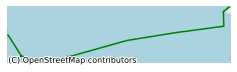
CE17007 GO-SHIP TransAtlantic Section A02
This survey took place in April-May 2017 on board the RV Celtic Explorer. The Marine Institute (MI) and National University of Ireland, Galway (NUIG) led an international partnership to complete the GO-SHIP A02 line. Onboard teams were from Canada, Germany, the UK, and the USA, and additional support from experts in Denmark and France. The A02 line runs from the margins of the Grand Banks, south of Newfoundland, to the shelf edge of the Celtic Sea off southern Ireland. Continuous underway measurements included surface seawater conductivity (salinity), temperature and partial pressure of carbon dioxide (pCO2), sampled via a hull water intake hose, and water current measurements to ~600 m depth using a vessel mounted Acoustic Doppler Current Profiler (ADCP). At predefined stations along the cruise track, approximately 30 nautical miles apart in the open ocean, the ship’s CTD sensor package and bottle rosette was deployed. Fitted with a range of calibrated sensors that measure conductivity, temperature and depth (CTD), dissolved oxygen relative fluorescence (chlorophyll), water clarity and water current measurements, the CTD carousel was lowered to just above the ocean floor and then brought back to the surface in an operation that took up to five hours at the deepest stations of > 4.8 km below the ocean surface. Ship-based hydrography is essential for documenting ocean changes throughout the water column, especially for the deep ocean below 2 km (52% of global ocean volume not sampled by profiling floats). Ship based platforms are the only current way to achieve high quality spatial and vertical measurement resolution. GO-SHIP is the only program that provides coincident comprehensive high resolution and quality, full depth inventory of key physical, carbon and biogeochemical observations. These measurements can validate the new generation of autonomous sensors on floats, gliders and buoys. GO-SHIP provides a ship-based platform for sensor development and assessment. GO-SHIP delivers data to GEO, and supports the products produced by the Carbon Dioxide Information Analysis Centre (CDIAC) based in the USA and the Surface Ocean CO2 Atlas (SOCAT). Objectives As part of an international programme, this A02 survey section is designed to be multidisciplinary in nature; to monitor and assess the ocean climate of waters to the west of Ireland and across the Atlantic to Canada. This contributes to an important global decadal time-series dataset; along a section that has been surveyed in the past. The main objectives are to: 1. Understand and document the large-scale ocean water property distributions, their changes, and drivers of those changes 2. Address questions of how a future ocean that will increase in dissolved inorganic carbon, become more acidic and more stratified, and experience changes in circulation and ventilation processes due to global warming, altered water cycle and sea-ice will interact with natural ocean variability.
Simple
- Date (Publication)
- 2017-12-20
- Date (Revision)
- 2023-06-01
- Date (Creation)
- 2017-12-20
- Citation identifier
- ie.marine.data:dataset.1498
- Point of contact
-
Organisation name Individual name Electronic mail address Role Marine Institute
Originator
- Maintenance and update frequency
- As needed
- SeaDataNet Parameter Discovery Vocabulary
-
- Vertical spatial coordinates
- Horizontal spatial co-ordinates
- Sea level
- Date and time
- SeaDataNet biological format biotic parameters
- Air pressure
- Air temperature
- Atmospheric humidity
- Wind strength and direction
- Platform or instrument orientation
- Salinity of the water column
- Temperature of the water column
- Use limitation
-
While every effort is made in preparing the dataset no responsibility is accepted by or on behalf of the Marine Institute for any errors, omissions or misleading information. The Marine Institute accepts no responsibility for loss or damage occasioned or claimed to have been occasioned, in part or in full, as a consequence of any person acting, or refraining from acting as a result of a matter contained in this datasets or as a consequence of using this dataset for any purpose whatsoever.
- Use limitation
-
A Creative Commons (CC) license is one of several public copyright licenses that enable the free distribution of an otherwise copyrighted work. A CC license is used when an author wants to give people the right to share, use, and build upon a work that they have created. Under Creative Commons CC BY 4.0 the following is granted: Rights Share — copy and redistribute the material in any medium or format; Adapt — remix, transform, and build upon the material for any purpose, even commercially. The licensor cannot revoke these freedoms as long as you follow the license terms. Requirements Attribution — You must give appropriate credit, provide a link to the license, and indicate if changes were made. You may do so in any reasonable manner, but not in any way that suggests the licensor endorses you or your use. No additional restrictions — You may not apply legal terms or technological measures that legally restrict others from doing anything the license permits.
- Access constraints
- CC%20BY%204.0
- Aggregate Datasetindentifier
- ie.marine.data:instrument.45
- Association Type
- Cross reference
- Initiative Type
- Sensor
- Aggregate Datasetindentifier
- ie.marine.data:instrument.47
- Association Type
- Cross reference
- Initiative Type
- Sensor
- Aggregate Datasetindentifier
- ie.marine.data:instrument.48
- Association Type
- Cross reference
- Initiative Type
- Sensor
- Aggregate Datasetindentifier
- ie.marine.data:instrument.161
- Association Type
- Cross reference
- Initiative Type
- Sensor
- Aggregate Datasetindentifier
- ie.marine.data:instrument.178
- Association Type
- Cross reference
- Initiative Type
- Sensor
- Aggregate Datasetindentifier
- ie.marine.data:instrument.179
- Association Type
- Cross reference
- Initiative Type
- Sensor
- Aggregate Datasetindentifier
- ie.marine.data:instrument.181
- Association Type
- Cross reference
- Initiative Type
- Sensor
- Aggregate Datasetindentifier
- ie.marine.data:instrument.195
- Association Type
- Cross reference
- Initiative Type
- Sensor
- Aggregate Datasetindentifier
- ie.marine.data:instrument.198
- Association Type
- Cross reference
- Initiative Type
- Sensor
- Aggregate Datasetindentifier
- ie.marine.data:instrument.199
- Association Type
- Cross reference
- Initiative Type
- Sensor
- Aggregate Datasetindentifier
- ie.marine.data:platform.33
- Association Type
- Cross reference
- Initiative Type
- Platform
- Aggregate Datasetindentifier
- ie.marine.data:dataset.845
- Association Type
- Cross reference
- Initiative Type
- Collection
- Aggregate Datasetindentifier
- ie.marine.data:dataset.848
- Association Type
- Cross reference
- Initiative Type
- Collection
- Aggregate Datasetindentifier
- ie.marine.data:dataset.2804
- Association Type
- Cross reference
- Initiative Type
- Collection
- Aggregate Datasetindentifier
- ie.marine.data:dataset.2932
- Association Type
- Cross reference
- Initiative Type
- Collection
- Spatial representation type
- Grid
- Language
- English
- Begin date
- 2017-04-26
- End date
- 2017-05-23
))
- Reference system identifier
- INSPIRE RS registry / http://www.opengis.net/def/crs/EPSG/0/3857
- Distribution format
-
Name Version CSV CTD Data
CSV Underway Data
- OnLine resource
-
Protocol Linkage Name WWW:LINK-1.0-http--link
http://www.marine.ie
- OnLine resource
-
Protocol Linkage Name WWW:LINK-1.0-http--link
https://www.dal.ca/faculty/science/oceanography.html
- Hierarchy level
- Dataset
Conformance result
- Title
-
Commission Regulation (EU) No 1089/2010 of 23 November 2010 implementing Directive 2007/2/EC of the European Parliament and of the Council as regards interoperability of spatial data sets and services
- Date (Publication)
- 2010-12-08
- Explanation
-
See the referenced specification
- Pass
- Yes
- Statement
-
Data supplied by Marine Institute.
Metadata
- File identifier
- ie.marine.data:dataset.1498 XML
- Metadata language
- English
- Hierarchy level
- Collection session
- Date stamp
- 2025-02-21T18:13:01.728911Z
- Metadata standard name
-
ISDI Metadata Profile
- Metadata standard version
-
1.2
- Metadata author
-
Organisation name Individual name Electronic mail address Role Marine Institute
Point of contact
)))
