 Irish Spatial Data Exchange
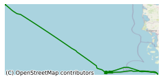
CE0913 Leibniz Institute of Marine Sciences at the University of Kiel North Sea Project Survey
This survey, led by The Leibniz Institute of Marine Sciences at the University of Kiel (IFM-Geomar) in the North Sea, was conducted in July-August 2009 Expedition CE0913 with RV CELTIC EXPLORER was conducted in the frame of the third-party-funded project "Fluid- and Gasseeps in the Southern German North Sea" between the 27th of July and 14th of August, 2009. The mission led into the shallow water zone of the German Bight (off the island of Juist) and subsequently to Tommeliten, a methane-seep field in the Norwegian sector of the North Sea The aim of the survey was to detect sites of active fluid and gas seepage in the North Sea, to decipher and map possible migration pathways in the Pleistocene and Holocene deposits, to quantify gas fluxes in the water column related to tides and currents, and to analyze the chemical compositions of emitted fluids and gases, in order to investigate relationship of fluid/gas seepage to subsurface reservoir geochemistry, sediment deposits and migration structures. Conventional echosounder, ADCP, and multi beam techniques are applied to get background information about sea surface morphology (e.g. pockmarks), shallow sediment characteristics and physical oceanography. Conductvity, Temperature and Depth casts was also carried out to profile the water column and to help detect gas seepage. Sediment and porewater studies were also performed during the cruise. The aim of the cruise was to detect sites of active fluid and gas seepage in the North Sea, to decipher and map possible migration pathways in the Pleistocene and Holocene deposits, to quantify gas fluxes in the water column related to tides and currents, and to analyze the chemical compositions of emitted fluids and gases, in order to investigate relationship of fluid/gas seepage to subsurface reservoir geochemistry, sediment deposits and migration structures.
Simple
- Date (Publication)
- 2017-11-24
- Date (Revision)
- 2023-06-01
- Date (Creation)
- 2017-11-24
- Citation identifier
- ie.marine.data:dataset.1137
- Point of contact
-
Organisation name Individual name Electronic mail address Role The Leibniz Institute of Marine Sciences at the University of Kiel
Originator
- Maintenance and update frequency
- As needed
- SeaDataNet Parameter Discovery Vocabulary
-
- Vertical spatial coordinates
- Horizontal spatial co-ordinates
- Sea level
- Date and time
- SeaDataNet biological format biotic parameters
- Air pressure
- Air temperature
- Atmospheric humidity
- Wind strength and direction
- Platform or instrument orientation
- Salinity of the water column
- Temperature of the water column
- Use limitation
-
While every effort is made in preparing the dataset no responsibility is accepted by or on behalf of the Marine Institute for any errors, omissions or misleading information. The Marine Institute accepts no responsibility for loss or damage occasioned or claimed to have been occasioned, in part or in full, as a consequence of any person acting, or refraining from acting as a result of a matter contained in this datasets or as a consequence of using this dataset for any purpose whatsoever.
- Use limitation
-
A Creative Commons (CC) license is one of several public copyright licenses that enable the free distribution of an otherwise copyrighted work. A CC license is used when an author wants to give people the right to share, use, and build upon a work that they have created. Under Creative Commons CC BY 4.0 the following is granted: Rights Share — copy and redistribute the material in any medium or format; Adapt — remix, transform, and build upon the material for any purpose, even commercially. The licensor cannot revoke these freedoms as long as you follow the license terms. Requirements Attribution — You must give appropriate credit, provide a link to the license, and indicate if changes were made. You may do so in any reasonable manner, but not in any way that suggests the licensor endorses you or your use. No additional restrictions — You may not apply legal terms or technological measures that legally restrict others from doing anything the license permits.
- Access constraints
- CC%20BY%204.0
- Aggregate Datasetindentifier
- ie.marine.data:instrument.45
- Association Type
- Cross reference
- Initiative Type
- Sensor
- Aggregate Datasetindentifier
- ie.marine.data:instrument.47
- Association Type
- Cross reference
- Initiative Type
- Sensor
- Aggregate Datasetindentifier
- ie.marine.data:instrument.48
- Association Type
- Cross reference
- Initiative Type
- Sensor
- Aggregate Datasetindentifier
- ie.marine.data:instrument.161
- Association Type
- Cross reference
- Initiative Type
- Sensor
- Aggregate Datasetindentifier
- ie.marine.data:instrument.180
- Association Type
- Cross reference
- Initiative Type
- Sensor
- Aggregate Datasetindentifier
- ie.marine.data:instrument.181
- Association Type
- Cross reference
- Initiative Type
- Sensor
- Aggregate Datasetindentifier
- ie.marine.data:instrument.182
- Association Type
- Cross reference
- Initiative Type
- Sensor
- Aggregate Datasetindentifier
- ie.marine.data:instrument.195
- Association Type
- Cross reference
- Initiative Type
- Sensor
- Aggregate Datasetindentifier
- ie.marine.data:instrument.198
- Association Type
- Cross reference
- Initiative Type
- Sensor
- Aggregate Datasetindentifier
- ie.marine.data:instrument.199
- Association Type
- Cross reference
- Initiative Type
- Sensor
- Aggregate Datasetindentifier
- ie.marine.data:platform.33
- Association Type
- Cross reference
- Initiative Type
- Platform
- Aggregate Datasetindentifier
- ie.marine.data:dataset.848
- Association Type
- Cross reference
- Initiative Type
- Collection
- Aggregate Datasetindentifier
- ie.marine.data:dataset.845
- Association Type
- Cross reference
- Initiative Type
- Collection
- Spatial representation type
- Grid
- Language
- English
- Begin date
- 2009-07-26
- End date
- 2009-08-14
))
- Reference system identifier
- INSPIRE RS registry / http://www.opengis.net/def/crs/EPSG/0/4326
- OnLine resource
-
Protocol Linkage Name WWW:LINK-1.0-http--link
http://www.marine.ie
- OnLine resource
-
Protocol Linkage Name WWW:LINK-1.0-http--link
http://www.seadatanet.org/
- Hierarchy level
- Dataset
Conformance result
- Title
-
Commission Regulation (EU) No 1089/2010 of 23 November 2010 implementing Directive 2007/2/EC of the European Parliament and of the Council as regards interoperability of spatial data sets and services
- Date (Publication)
- 2010-12-08
- Explanation
-
See the referenced specification
- Pass
- Yes
- Statement
-
Data supplied by Marine Institute.
Metadata
- File identifier
- ie.marine.data:dataset.1137 XML
- Metadata language
- English
- Hierarchy level
- Collection session
- Date stamp
- 2025-02-21T18:11:42.74884Z
- Metadata standard name
-
ISDI Metadata Profile
- Metadata standard version
-
1.2
- Metadata author
-
Organisation name Individual name Electronic mail address Role Marine Institute
Point of contact
)))
