 Irish Spatial Data Exchange
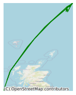
CE0910 SALSEA Survey
SALSEA-Merge was a three year scientific project to investigate the migration and distribution of salmon in the North-East Atlantic. The project was supported by the European Commission under the 7th Framework Programme for Research and Technological development. Funding was also provided by the Partner organisations, the Total Foundation and the Atlantic Salmon Trust. SALSEA-Merge was officially launched on the 16 May 2008 in Killybegs, Ireland. This survey took place in the summer of 2009 on board the Marine Institute's R.V. Celtic Explorer in the North East Atlantic Ocean and Norwegian Sea. Trawling was carried out to sample post salmon smolts and other pelagic fish. CTD (Conductivity - Temperature - Depth) profiles were carried out to profile the water column. The overall objective of SALSEA-Marge is, by merging genetic and ecological investigations, to advance understanding of stock specific migration and distribution patterns and overall ecology of the marine life of Atlantic Salmon and gain an insight into the factors resulting in significant increases in mortality at the time.
Simple
- Date (Publication)
- 2017-11-24
- Date (Revision)
- 2018-11-29
- Date (Creation)
- 2017-11-24
- Citation identifier
- ie.marine.data:dataset.1133
- Point of contact
-
Organisation name Individual name Electronic mail address Role Marine Institute
Originator
- Maintenance and update frequency
- As needed
- SeaDataNet Parameter Discovery Vocabulary
-
- Vertical spatial coordinates
- Horizontal spatial co-ordinates
- Sea level
- Date and time
- SeaDataNet biological format biotic parameters
- Air pressure
- Air temperature
- Atmospheric humidity
- Wind strength and direction
- Platform or instrument orientation
- Salinity of the water column
- Temperature of the water column
- Use limitation
-
While every effort is made in preparing the dataset no responsibility is accepted by or on behalf of the Marine Institute for any errors, omissions or misleading information. The Marine Institute accepts no responsibility for loss or damage occasioned or claimed to have been occasioned, in part or in full, as a consequence of any person acting, or refraining from acting as a result of a matter contained in this datasets or as a consequence of using this dataset for any purpose whatsoever.
- Use limitation
-
A Creative Commons (CC) license is one of several public copyright licenses that enable the free distribution of an otherwise copyrighted work. A CC license is used when an author wants to give people the right to share, use, and build upon a work that they have created. Under Creative Commons CC BY 4.0 the following is granted: Rights Share — copy and redistribute the material in any medium or format; Adapt — remix, transform, and build upon the material for any purpose, even commercially. The licensor cannot revoke these freedoms as long as you follow the license terms. Requirements Attribution — You must give appropriate credit, provide a link to the license, and indicate if changes were made. You may do so in any reasonable manner, but not in any way that suggests the licensor endorses you or your use. No additional restrictions — You may not apply legal terms or technological measures that legally restrict others from doing anything the license permits.
- Access constraints
- CC%20BY%204.0
- Aggregate Datasetindentifier
- ie.marine.data:instrument.45
- Association Type
- Cross reference
- Initiative Type
- Sensor
- Aggregate Datasetindentifier
- ie.marine.data:instrument.47
- Association Type
- Cross reference
- Initiative Type
- Sensor
- Aggregate Datasetindentifier
- ie.marine.data:instrument.48
- Association Type
- Cross reference
- Initiative Type
- Sensor
- Aggregate Datasetindentifier
- ie.marine.data:instrument.161
- Association Type
- Cross reference
- Initiative Type
- Sensor
- Aggregate Datasetindentifier
- ie.marine.data:instrument.180
- Association Type
- Cross reference
- Initiative Type
- Sensor
- Aggregate Datasetindentifier
- ie.marine.data:instrument.181
- Association Type
- Cross reference
- Initiative Type
- Sensor
- Aggregate Datasetindentifier
- ie.marine.data:instrument.182
- Association Type
- Cross reference
- Initiative Type
- Sensor
- Aggregate Datasetindentifier
- ie.marine.data:instrument.195
- Association Type
- Cross reference
- Initiative Type
- Sensor
- Aggregate Datasetindentifier
- ie.marine.data:instrument.198
- Association Type
- Cross reference
- Initiative Type
- Sensor
- Aggregate Datasetindentifier
- ie.marine.data:instrument.199
- Association Type
- Cross reference
- Initiative Type
- Sensor
- Aggregate Datasetindentifier
- ie.marine.data:instrument.1488
- Association Type
- Cross reference
- Initiative Type
- Sensor
- Aggregate Datasetindentifier
- ie.marine.data:instrument.1489
- Association Type
- Cross reference
- Initiative Type
- Sensor
- Aggregate Datasetindentifier
- ie.marine.data:instrument.1490
- Association Type
- Cross reference
- Initiative Type
- Sensor
- Aggregate Datasetindentifier
- ie.marine.data:instrument.1491
- Association Type
- Cross reference
- Initiative Type
- Sensor
- Aggregate Datasetindentifier
- ie.marine.data:instrument.1492
- Association Type
- Cross reference
- Initiative Type
- Sensor
- Aggregate Datasetindentifier
- ie.marine.data:platform.33
- Association Type
- Cross reference
- Initiative Type
- Platform
- Aggregate Datasetindentifier
- ie.marine.data:dataset.848
- Association Type
- Cross reference
- Initiative Type
- Collection
- Aggregate Datasetindentifier
- ie.marine.data:dataset.845
- Association Type
- Cross reference
- Initiative Type
- Collection
- Aggregate Datasetindentifier
- ie.marine.data:dataset.1261
- Association Type
- Cross reference
- Initiative Type
- Collection
- Spatial representation type
- Grid
- Language
- English
- Begin date
- 2009-06-23
- End date
- 2009-07-02
))
- Reference system identifier
- INSPIRE RS registry / http://www.opengis.net/def/crs/EPSG/0/3857
- OnLine resource
-
Protocol Linkage Name WWW:LINK-1.0-http--link
http://www.marine.ie
- OnLine resource
-
Protocol Linkage Name WWW:LINK-1.0-http--link
http://www.nasco.int/sas/salsea.htm
- Hierarchy level
- Dataset
Conformance result
- Title
-
Commission Regulation (EU) No 1089/2010 of 23 November 2010 implementing Directive 2007/2/EC of the European Parliament and of the Council as regards interoperability of spatial data sets and services
- Date (Publication)
- 2010-12-08
- Explanation
-
See the referenced specification
- Pass
- Yes
- Statement
-
Data supplied by Marine Institute.
Metadata
- File identifier
- ie.marine.data:dataset.1133 XML
- Metadata language
- English
- Hierarchy level
- Collection session
- Date stamp
- 2025-02-21T18:11:39.252347Z
- Metadata standard name
-
ISDI Metadata Profile
- Metadata standard version
-
1.2
- Metadata author
-
Organisation name Individual name Electronic mail address Role Marine Institute
Point of contact
)))
