 Irish Spatial Data Exchange
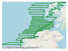
CE13009 Celtic Explorer North West Ireland Herring Acoustic Survey 2013
This survey was conducted by the Marine Institute on-board the RV Celtic Explorer in summer 2013 as part of the North West Herring Acoustic Survey. The northwest and west coast (ICES Divisions VIaS and VIIb) herring acoustic survey programme was first established in 1994. The summer 2013 survey represents the sixth in the new time series, starting in 2008. The survey was coordinated through the ICES Working Group of International Pelagic Surveys (WGIPS). Survey data on stock numbers at age are submitted to the ICES Herring Assessment Working Group (HAWG) and used in the annual stock assessment process. The northwest and west coast (ICES Divisions VIaS and VIIb) herring stock is composed of two spawning components, autumn and winter spawners. Spawning covers a large geographical area and extends over a 4-month period from late September through to late March. Traditionally, fishing effort has been concentrated on spawning and pre-spawning aggregations. The autumn spawning component, which mostly occurs within VIIb and VIaS, feeds along the shelf break area to the west of the spawning grounds. The winter spawning component is found further north in VIaS. In VIaS, summer distribution extends from close inshore to the shelf break. Components of the winter spawning fish are known to undertake northward feeding migration into VIaN before returning in the winter to spawn along the Irish coast. This survey, carried out between 22nd June and 12th July, focused on the northwest and west coast of Ireland and the west coast of Scotland. The survey track started to the southeast of the Isle of Coll, zigzagged north through the Minches (between the Scottish mainland and the Hebrides), then worked progressively southwards in parallel eastwest transects, and finished near the mouth of Killary Harbour. A systematic parallel transect design was adopted for the majority of the survey, with a randomised start point. Transects were positioned running perpendicular to the lines of bathymetry where possible. To keep in line with existing survey methodology acoustic data collection was only undertaken during daylight hours (04:00 and 00:00). The acoustic data were collected using the Simrad ER60 scientific echosounder. For biological sampling, a single pelagic midwater trawl was used. 22 hauls were carried out. All components of the catch from the trawl hauls were sorted and weighed; fish and other taxa were identified to species level. Oceanographic stations were carried out during the survey at predetermined locations along the track. A marine mammal observer was also present to conduct visual surveys of marine mammals and seabirds.. The aim of the acoustic survey is to determine the relative abundance of the target species, herring. This information is then used to determine catch rates and management advice for the following year. Other objectives include collecting physical oceanography (CTD) data and visual surveys for marine mammals and seabirds. Acoustic and biological data on boarfish (Capros aper) was also collected for the Boarfish Acoustic Survey, 2013.
Simple
- Date (Publication)
- 2017-11-24
- Date (Revision)
- 2023-06-01
- Date (Creation)
- 2017-11-24
- Citation identifier
- ie.marine.data:dataset.1089
- Point of contact
-
Organisation name Individual name Electronic mail address Role Marine Institute
Originator
- Maintenance and update frequency
- As needed
- SeaDataNet Parameter Discovery Vocabulary
-
- Vertical spatial coordinates
- Horizontal spatial co-ordinates
- Sea level
- Date and time
- SeaDataNet biological format biotic parameters
- Air pressure
- Air temperature
- Atmospheric humidity
- Wind strength and direction
- Platform or instrument orientation
- Bathymetry and Elevation
- Salinity of the water column
- Temperature of the water column
- Use limitation
-
While every effort is made in preparing the dataset no responsibility is accepted by or on behalf of the Marine Institute for any errors, omissions or misleading information. The Marine Institute accepts no responsibility for loss or damage occasioned or claimed to have been occasioned, in part or in full, as a consequence of any person acting, or refraining from acting as a result of a matter contained in this datasets or as a consequence of using this dataset for any purpose whatsoever.
- Use limitation
-
A Creative Commons (CC) license is one of several public copyright licenses that enable the free distribution of an otherwise copyrighted work. A CC license is used when an author wants to give people the right to share, use, and build upon a work that they have created. Under Creative Commons CC BY 4.0 the following is granted: Rights Share — copy and redistribute the material in any medium or format; Adapt — remix, transform, and build upon the material for any purpose, even commercially. The licensor cannot revoke these freedoms as long as you follow the license terms. Requirements Attribution — You must give appropriate credit, provide a link to the license, and indicate if changes were made. You may do so in any reasonable manner, but not in any way that suggests the licensor endorses you or your use. No additional restrictions — You may not apply legal terms or technological measures that legally restrict others from doing anything the license permits.
- Access constraints
- CC%20BY%204.0
- Aggregate Datasetindentifier
- ie.marine.data:instrument.45
- Association Type
- Cross reference
- Initiative Type
- Sensor
- Aggregate Datasetindentifier
- ie.marine.data:instrument.47
- Association Type
- Cross reference
- Initiative Type
- Sensor
- Aggregate Datasetindentifier
- ie.marine.data:instrument.48
- Association Type
- Cross reference
- Initiative Type
- Sensor
- Aggregate Datasetindentifier
- ie.marine.data:instrument.161
- Association Type
- Cross reference
- Initiative Type
- Sensor
- Aggregate Datasetindentifier
- ie.marine.data:instrument.180
- Association Type
- Cross reference
- Initiative Type
- Sensor
- Aggregate Datasetindentifier
- ie.marine.data:instrument.181
- Association Type
- Cross reference
- Initiative Type
- Sensor
- Aggregate Datasetindentifier
- ie.marine.data:instrument.182
- Association Type
- Cross reference
- Initiative Type
- Sensor
- Aggregate Datasetindentifier
- ie.marine.data:instrument.190
- Association Type
- Cross reference
- Initiative Type
- Sensor
- Aggregate Datasetindentifier
- ie.marine.data:instrument.195
- Association Type
- Cross reference
- Initiative Type
- Sensor
- Aggregate Datasetindentifier
- ie.marine.data:instrument.198
- Association Type
- Cross reference
- Initiative Type
- Sensor
- Aggregate Datasetindentifier
- ie.marine.data:instrument.199
- Association Type
- Cross reference
- Initiative Type
- Sensor
- Aggregate Datasetindentifier
- ie.marine.data:instrument.220
- Association Type
- Cross reference
- Initiative Type
- Sensor
- Aggregate Datasetindentifier
- ie.marine.data:instrument.1291
- Association Type
- Cross reference
- Initiative Type
- Sensor
- Aggregate Datasetindentifier
- ie.marine.data:instrument.1293
- Association Type
- Cross reference
- Initiative Type
- Sensor
- Aggregate Datasetindentifier
- ie.marine.data:instrument.1415
- Association Type
- Cross reference
- Initiative Type
- Sensor
- Aggregate Datasetindentifier
- ie.marine.data:instrument.1416
- Association Type
- Cross reference
- Initiative Type
- Sensor
- Aggregate Datasetindentifier
- ie.marine.data:instrument.1417
- Association Type
- Cross reference
- Initiative Type
- Sensor
- Aggregate Datasetindentifier
- ie.marine.data:platform.33
- Association Type
- Cross reference
- Initiative Type
- Platform
- Aggregate Datasetindentifier
- ie.marine.data:dataset.848
- Association Type
- Cross reference
- Initiative Type
- Collection
- Aggregate Datasetindentifier
- ie.marine.data:dataset.845
- Association Type
- Cross reference
- Initiative Type
- Collection
- Aggregate Datasetindentifier
- ie.marine.data:dataset.726
- Association Type
- Cross reference
- Initiative Type
- Collection
- Aggregate Datasetindentifier
- ie.marine.data:dataset.709
- Association Type
- Cross reference
- Initiative Type
- Collection
- Aggregate Datasetindentifier
- ie.marine.data:dataset.1231
- Association Type
- Cross reference
- Initiative Type
- Collection
- Aggregate Datasetindentifier
- ie.marine.data:dataset.854
- Association Type
- Cross reference
- Initiative Type
- Collection
- Spatial representation type
- Grid
- Language
- English
- Begin date
- 2013-06-21
- End date
- 2013-07-12
))
- Reference system identifier
- INSPIRE RS registry / http://www.opengis.net/def/crs/EPSG/0/3857
- Distribution format
-
Name Version CSV CTD Data
CSV Underway Data
- OnLine resource
-
Protocol Linkage Name WWW:LINK-1.0-http--link
http://www.marine.ie
- OnLine resource
-
Protocol Linkage Name WWW:LINK-1.0-http--link
https://www.marine.ie/Home/site-area/areas-activity/fisheries-ecosystems/acoustic-surveys
- Hierarchy level
- Dataset
Conformance result
- Title
-
Commission Regulation (EU) No 1089/2010 of 23 November 2010 implementing Directive 2007/2/EC of the European Parliament and of the Council as regards interoperability of spatial data sets and services
- Date (Publication)
- 2010-12-08
- Explanation
-
See the referenced specification
- Pass
- Yes
- Statement
-
Data supplied by Marine Institute.
Metadata
- File identifier
- ie.marine.data:dataset.1089 XML
- Metadata language
- English
- Hierarchy level
- Collection session
- Date stamp
- 2025-02-21T18:11:54.43022Z
- Metadata standard name
-
ISDI Metadata Profile
- Metadata standard version
-
1.2
- Metadata author
-
Organisation name Individual name Electronic mail address Role Marine Institute
Point of contact
)))
