 Irish Spatial Data Exchange
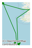
CE13008 Celtic Explorer Biodiscovery and Ecosystem Function of Canyons Survey 2013
This three week research survey led by National University of Ireland, Galway (NUIG) took place on board the Marine Institute's R.V. Celtic Explorer in June/July 2013. The Biodiscovery and Ecosystem Function of Canyons Survey investigated a wide diversity of habitats and underwater communities in the Whittard Canyon system on the Irish Atlantic margin. Whittard Canyon is one of many subsea canyons that incise the eastern margin of the North Atlantic. The research team used the Marine Institute’s Deepwater Remotely Operated Vehicle (ROV), Holland 1, to collect to specimens of coral, sponges, sediment samples and other marine organisms. CTD (Conductivity, Temperature and Depth) profiles were conducted at the ROV stations. This survey was conducted as part of an ongoing effort to understand Ireland’s deep-sea biodiversity. SCIENTIFIC OBJECTIVES (i) identify and map benthic macrofauna using conventional cores and ROV surveys; (ii) improve systematic knowledge of Porifera and Mollusca, groups with known biodiscovery potential, using traditional morphological techniques in combination with molecular biology; (iii) collect marine specimens for freeze-drying, the preparation of extracts in the MI Marine Biodiscovery Laboratory and screening of bioactivity within the Beaufort Biodiscovery Consortium; (iv) collect deep-sea sediment likely to harbour micro-organisms capable of producing novel bioactives; (v) collect marine specimens likely to have novel photoactive molecules; (vi) characterize bacterial and archaeal diversity in deep sea water and sediment samples over spatial and temporal scales; and (vii) collect marine invertebrate samples (particularly sponges), seawater samples, and marine sediment to study and compare the microbiota associated with each of the samples, culture microorganisms and construct metagenomic libraries.
Simple
- Date (Publication)
- 2017-11-24
- Date (Revision)
- 2021-02-25
- Date (Creation)
- 2017-11-24
- Citation identifier
- ie.marine.data:dataset.1085
- Point of contact
-
Organisation name Individual name Electronic mail address Role University of Galway
Originator
- Maintenance and update frequency
- As needed
- SeaDataNet Parameter Discovery Vocabulary
-
- Vertical spatial coordinates
- Horizontal spatial co-ordinates
- Sea level
- Date and time
- SeaDataNet biological format biotic parameters
- Air pressure
- Air temperature
- Atmospheric humidity
- Wind strength and direction
- Platform or instrument orientation
- Salinity of the water column
- Temperature of the water column
- Use limitation
-
While every effort is made in preparing the dataset no responsibility is accepted by or on behalf of the Marine Institute for any errors, omissions or misleading information. The Marine Institute accepts no responsibility for loss or damage occasioned or claimed to have been occasioned, in part or in full, as a consequence of any person acting, or refraining from acting as a result of a matter contained in this datasets or as a consequence of using this dataset for any purpose whatsoever.
- Use limitation
-
A Creative Commons (CC) license is one of several public copyright licenses that enable the free distribution of an otherwise copyrighted work. A CC license is used when an author wants to give people the right to share, use, and build upon a work that they have created. Under Creative Commons CC BY 4.0 the following is granted: Rights Share — copy and redistribute the material in any medium or format; Adapt — remix, transform, and build upon the material for any purpose, even commercially. The licensor cannot revoke these freedoms as long as you follow the license terms. Requirements Attribution — You must give appropriate credit, provide a link to the license, and indicate if changes were made. You may do so in any reasonable manner, but not in any way that suggests the licensor endorses you or your use. No additional restrictions — You may not apply legal terms or technological measures that legally restrict others from doing anything the license permits.
- Access constraints
- CC%20BY%204.0
- Aggregate Datasetindentifier
- ie.marine.data:instrument.45
- Association Type
- Cross reference
- Initiative Type
- Sensor
- Aggregate Datasetindentifier
- ie.marine.data:instrument.47
- Association Type
- Cross reference
- Initiative Type
- Sensor
- Aggregate Datasetindentifier
- ie.marine.data:instrument.48
- Association Type
- Cross reference
- Initiative Type
- Sensor
- Aggregate Datasetindentifier
- ie.marine.data:instrument.161
- Association Type
- Cross reference
- Initiative Type
- Sensor
- Aggregate Datasetindentifier
- ie.marine.data:instrument.180
- Association Type
- Cross reference
- Initiative Type
- Sensor
- Aggregate Datasetindentifier
- ie.marine.data:instrument.181
- Association Type
- Cross reference
- Initiative Type
- Sensor
- Aggregate Datasetindentifier
- ie.marine.data:instrument.182
- Association Type
- Cross reference
- Initiative Type
- Sensor
- Aggregate Datasetindentifier
- ie.marine.data:instrument.195
- Association Type
- Cross reference
- Initiative Type
- Sensor
- Aggregate Datasetindentifier
- ie.marine.data:instrument.198
- Association Type
- Cross reference
- Initiative Type
- Sensor
- Aggregate Datasetindentifier
- ie.marine.data:instrument.199
- Association Type
- Cross reference
- Initiative Type
- Sensor
- Aggregate Datasetindentifier
- ie.marine.data:platform.33
- Association Type
- Cross reference
- Initiative Type
- Platform
- Aggregate Datasetindentifier
- ie.marine.data:dataset.848
- Association Type
- Cross reference
- Initiative Type
- Collection
- Aggregate Datasetindentifier
- ie.marine.data:dataset.845
- Association Type
- Cross reference
- Initiative Type
- Collection
- Spatial representation type
- Grid
- Language
- English
- Begin date
- 2013-05-29
- End date
- 2013-06-21
))
- Reference system identifier
- INSPIRE RS registry / http://www.opengis.net/def/crs/EPSG/0/3857
- Distribution format
-
Name Version CSV CTD Data
CSV Underway Data
Shapefile
- OnLine resource
-
Protocol Linkage Name WWW:LINK-1.0-http--link
http://www.marine.ie
- OnLine resource
-
Protocol Linkage Name WWW:LINK-1.0-http--link
http://www.seadatanet.org/
- OnLine resource
-
Protocol Linkage Name WWW:DOWNLOAD-1.0-http--download
https://atlas.marine.ie/midata/OceanFeatures/Marine_Institute_CTD.shapezip.zip Shapefile
- Hierarchy level
- Dataset
Conformance result
- Title
-
Commission Regulation (EU) No 1089/2010 of 23 November 2010 implementing Directive 2007/2/EC of the European Parliament and of the Council as regards interoperability of spatial data sets and services
- Date (Publication)
- 2010-12-08
- Explanation
-
See the referenced specification
- Pass
- Yes
- Statement
-
Data supplied by Marine Institute.
Metadata
- File identifier
- ie.marine.data:dataset.1085 XML
- Metadata language
- English
- Hierarchy level
- Collection session
- Date stamp
- 2025-02-21T18:11:53.97581Z
- Metadata standard name
-
ISDI Metadata Profile
- Metadata standard version
-
1.2
- Metadata author
-
Organisation name Individual name Electronic mail address Role Marine Institute
Point of contact
)))
