 Irish Spatial Data Exchange
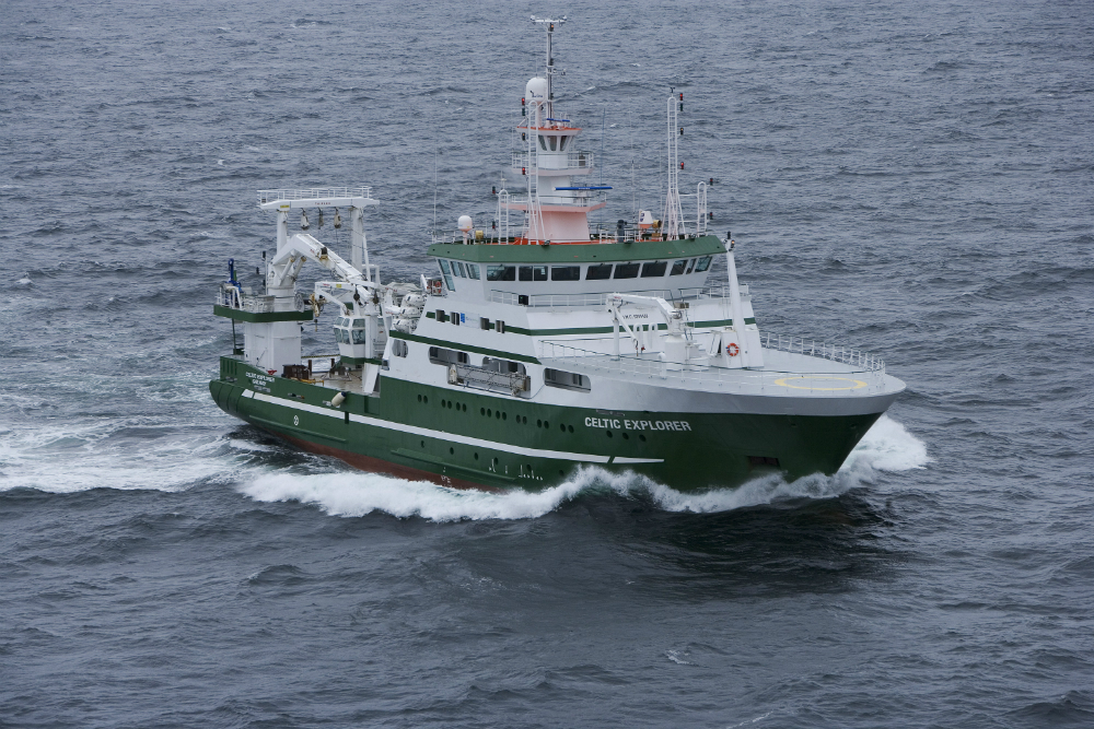
CE0705 INFOMAR Seabed Survey
This survey took place onboard the R/V Celtic Explorer on behalf of the MESH (Mapping European Seabed Habitats) European Union INTERREG IIIb project. The cruise took place between the 4th and 18th of June 2007. The study area is located 320km to the southwest of Land’s End . The area surveyed comprises continental shelf sloping south-westwards to the shelfbreak which occurs at a depth of approximately 200m. From there it passes down to the much steeper, deeply incised (canyoned) continental slope. The area surveyed includes two canyons and the eastern flank of a third canyon, straddling the UK/Irish median line. Due to the constraints of the multibeam system used for this survey, no data could be collected in water depths greater than 1165m. The objectives of the R/V Celtic Explorer cruise were to collect high-resolution bathymetry, backscatter, sub-bottom and camera data from the submarine canyons located in the South West Approaches. These canyons were being investigated to confirm the presence of habitats listed in Annex I of the EC Habitats Directive 92/43/EEC (EC, 1992), in particular Annex I reef habitat and to test the application of the MESH Guidance framework for seabed habitat mapping, covering all stages of a project from planning through survey, analysis, map production and finally the practical application of maps for environmental management.
Simple
- Date (Publication)
- 2017-11-21
- Date (Revision)
- 2018-11-29
- Date (Creation)
- 2017-11-21
- Citation identifier
- ie.marine.data:dataset.1024
- Point of contact
-
Organisation name Individual name Electronic mail address Role Marine Institute
Originator
- Maintenance and update frequency
- As needed
- SeaVoX Device Catalogue
-
- 1-metre ring net
- anemometer
- Kongsberg EM 302 multibeam echosounder
- Marine Magnetics SeaSPY Marine magnetometer
- Sea-Bird SBE 21 Thermosalinograph
- Sea-Bird SBE 35 thermometer
- Sea-Bird SBE 3plus (SBE 3P) temperature sensor
- Sea-Bird SBE 4C conductivity sensor
- Sea-Bird SBE 911plus CTD
- Vaisala HMP temperature and humidity sensor
- Van Veen grab
- SeaDataNet Parameter Discovery Vocabulary
-
- Vertical spatial coordinates
- Horizontal spatial co-ordinates
- Sea level
- Date and time
- SeaDataNet biological format biotic parameters
- Air pressure
- Air temperature
- Atmospheric humidity
- Wind strength and direction
- Platform or instrument orientation
- Bathymetry and Elevation
- Acoustic noise in the water column
- Salinity of the water column
- Sound velocity and travel time in the water column
- Temperature of the water column
- Use limitation
-
While every effort is made in preparing the dataset no responsibility is accepted by or on behalf of the Marine Institute for any errors, omissions or misleading information. The Marine Institute accepts no responsibility for loss or damage occasioned or claimed to have been occasioned, in part or in full, as a consequence of any person acting, or refraining from acting as a result of a matter contained in this datasets or as a consequence of using this dataset for any purpose whatsoever.
- Use limitation
-
A Creative Commons (CC) license is one of several public copyright licenses that enable the free distribution of an otherwise copyrighted work. A CC license is used when an author wants to give people the right to share, use, and build upon a work that they have created. Under Creative Commons CC BY 4.0 the following is granted: Rights Share — copy and redistribute the material in any medium or format; Adapt — remix, transform, and build upon the material for any purpose, even commercially. The licensor cannot revoke these freedoms as long as you follow the license terms. Requirements Attribution — You must give appropriate credit, provide a link to the license, and indicate if changes were made. You may do so in any reasonable manner, but not in any way that suggests the licensor endorses you or your use. No additional restrictions — You may not apply legal terms or technological measures that legally restrict others from doing anything the license permits.
- Access constraints
- CC%20BY%204.0
- Aggregate Datasetindentifier
- ie.marine.data:instrument.45
- Association Type
- Cross reference
- Initiative Type
- Sensor
- Aggregate Datasetindentifier
- ie.marine.data:instrument.47
- Association Type
- Cross reference
- Initiative Type
- Sensor
- Aggregate Datasetindentifier
- ie.marine.data:instrument.48
- Association Type
- Cross reference
- Initiative Type
- Sensor
- Aggregate Datasetindentifier
- ie.marine.data:instrument.161
- Association Type
- Cross reference
- Initiative Type
- Sensor
- Aggregate Datasetindentifier
- ie.marine.data:instrument.180
- Association Type
- Cross reference
- Initiative Type
- Sensor
- Aggregate Datasetindentifier
- ie.marine.data:instrument.181
- Association Type
- Cross reference
- Initiative Type
- Sensor
- Aggregate Datasetindentifier
- ie.marine.data:instrument.182
- Association Type
- Cross reference
- Initiative Type
- Sensor
- Aggregate Datasetindentifier
- ie.marine.data:instrument.190
- Association Type
- Cross reference
- Initiative Type
- Sensor
- Aggregate Datasetindentifier
- ie.marine.data:instrument.192
- Association Type
- Cross reference
- Initiative Type
- Sensor
- Aggregate Datasetindentifier
- ie.marine.data:instrument.195
- Association Type
- Cross reference
- Initiative Type
- Sensor
- Aggregate Datasetindentifier
- ie.marine.data:instrument.198
- Association Type
- Cross reference
- Initiative Type
- Sensor
- Aggregate Datasetindentifier
- ie.marine.data:instrument.199
- Association Type
- Cross reference
- Initiative Type
- Sensor
- Aggregate Datasetindentifier
- ie.marine.data:instrument.215
- Association Type
- Cross reference
- Initiative Type
- Sensor
- Aggregate Datasetindentifier
- ie.marine.data:instrument.237
- Association Type
- Cross reference
- Initiative Type
- Sensor
- Aggregate Datasetindentifier
- ie.marine.data:instrument.813
- Association Type
- Cross reference
- Initiative Type
- Sensor
- Aggregate Datasetindentifier
- ie.marine.data:instrument.1426
- Association Type
- Cross reference
- Initiative Type
- Sensor
- Aggregate Datasetindentifier
- ie.marine.data:instrument.1428
- Association Type
- Cross reference
- Initiative Type
- Sensor
- Aggregate Datasetindentifier
- ie.marine.data:platform.33
- Association Type
- Cross reference
- Initiative Type
- Platform
- Aggregate Datasetindentifier
- ie.marine.data:dataset.848
- Association Type
- Cross reference
- Initiative Type
- Collection
- Aggregate Datasetindentifier
- ie.marine.data:dataset.858
- Association Type
- Cross reference
- Initiative Type
- Collection
- Aggregate Datasetindentifier
- ie.marine.data:dataset.860
- Association Type
- Cross reference
- Initiative Type
- Collection
- Aggregate Datasetindentifier
- ie.marine.data:dataset.862
- Association Type
- Cross reference
- Initiative Type
- Collection
- Aggregate Datasetindentifier
- ie.marine.data:dataset.867
- Association Type
- Cross reference
- Initiative Type
- Collection
- Aggregate Datasetindentifier
- ie.marine.data:dataset.897
- Association Type
- Cross reference
- Initiative Type
- Collection
- Aggregate Datasetindentifier
- ie.marine.data:dataset.901
- Association Type
- Cross reference
- Initiative Type
- Collection
- Aggregate Datasetindentifier
- ie.marine.data:dataset.845
- Association Type
- Cross reference
- Initiative Type
- Collection
- Spatial representation type
- Grid
- Language
- English
- Begin date
- 2007-06-04
- End date
- 2007-06-18
))
- Reference system identifier
- INSPIRE RS registry / http://www.opengis.net/def/crs/EPSG/0/3857
- Distribution format
-
Name Version CSV CTD Data
CSV Underway Data
- OnLine resource
-
Protocol Linkage Name WWW:LINK-1.0-http--link
http://www.infomar.ie/
- OnLine resource
-
Protocol Linkage Name WWW:LINK-1.0-http--link
http://www.marine.ie
- OnLine resource
-
Protocol Linkage Name WWW:LINK-1.0-http--link
https://www.gsi.ie/
- Hierarchy level
- Dataset
Conformance result
- Title
-
Commission Regulation (EU) No 1089/2010 of 23 November 2010 implementing Directive 2007/2/EC of the European Parliament and of the Council as regards interoperability of spatial data sets and services
- Date (Publication)
- 2010-12-08
- Explanation
-
See the referenced specification
- Pass
- Yes
- Statement
-
Data supplied by Marine Institute.
Metadata
- File identifier
- ie.marine.data:dataset.1024 XML
- Metadata language
- English
- Hierarchy level
- Collection session
- Date stamp
- 2025-02-21T18:12:13.999338Z
- Metadata standard name
-
ISDI Metadata Profile
- Metadata standard version
-
1.2
- Metadata author
-
Organisation name Individual name Electronic mail address Role Marine Institute
Point of contact
)))
