 Irish Spatial Data Exchange
Farm and Landscape measures for Agriculture
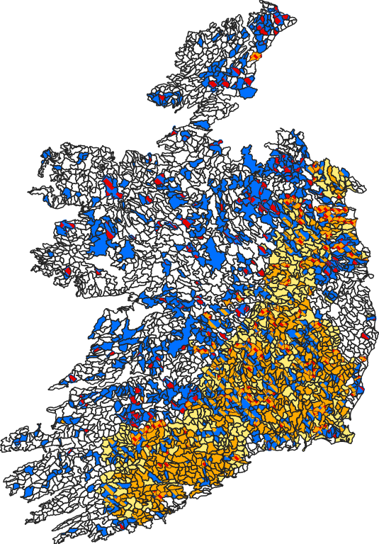
Where agricultural measures are needed to restore water quality, the Subbasin are highlighted with one or more coloured flags to indicate the types of water quality issues associated with that Subbasin: Red (potential point source), Orange (nitrate losses) and/or Navy (phosphorus/sediment losses).
Simple
- Alternate title
-
Farm and Landscape measures for Agriculture
- Date (Creation)
- 2023-01-20T00:00:00
- Date (Publication)
- 2023-02-08T00:00:00
- Date (Revision)
- 2025-08-25T00:00:00
- Citation identifier
- Targeting_Agricultural_Measures
- Purpose
-
A 'Coloured Flag' system has been developed to support targeting agricultural measures to get the right measure in the right place. The outputs for all Subbasins incorporate key national datasets and assign flags to indicate the potential water quality issues to focus on.
Where agricultural measures are needed to restore water quality, one or more coloured flags indicate the types of water quality issues associated with that Subbasin:
• Red (potential point source), Orange (nitrate losses) and/or Navy (phosphorus/sediment losses).
• The White Flag indicates Subbasins where agriculture is not identified as a significant pressure and measures to 'Protect' water quality are appropriate.
These flags indicate potential impacts arising from agricultural to facilitate targeting actions and should be combined with local knowledge and evidence. These will be reviewed annually.
- Status
- On going
- Point of contact
-
Organisation name Individual name Electronic mail address Role Environmental Protection Agency
GIS Team
Point of contact
- Maintenance and update frequency
- As needed
-
GemetInspireTheme
-
-
Environmental monitoring facilities
-
-
GEMET - Concepts, version 3.1
-
-
hydrography
-
catchment
-
agriculture
-
-
Environmental Protection Agency
-
-
hydrography
-
Targeting Agricultural Measures
-
water quality
-
nitrogen
-
phosphorus
-
catchment
-
-
ISO 3166
-
-
IE
-
- Use limitation
-
no limitations
- Use limitation
-
Data is for public use under Creative Commons CC-By 4.0
- Access constraints
- License
- Use constraints
- License
- Other constraints
- Spatial representation type
- Vector
- Denominator
- 50000
- Language
- English
- Character set
- UTF8
- Topic category
-
- Environment
))
- Begin date
- 2017-01-01T00:00:00
- End date
- 2017-01-01T00:00:00
Vertical extent
- Minimum value
- 0
- Maximum value
- 1014
Vertical CS
Vertical datum
- Reference system identifier
-
http://www.opengis.net/def/crs/EPSG/0/29902
EPSG Geodetic Parameter Dataset EPSG 2009-11-25
- Distribution format
-
Name Version comma-separated values (CSV)
N/A
- Distributor contact
-
Organisation name Individual name Electronic mail address Role Environmental Protection Agency
GIS Team
Publisher
- OnLine resource
-
Protocol Linkage Name application/json
http://gis.epa.ie/geoserver/EPA/ows?service=WFS&version=1.0.0&request=GetFeature&typeName=EPA%3ASubBasins_AgMeasures2023&maxFeatures=50&outputFormat=application%2Fjson GeoJSON Get Map
- OnLine resource
- Hierarchy level
- Dataset
Conformance result
- Title
-
INSPIRE Data Specification on Environmental monitoring facilities
- Alternate title
-
INSPIRE Data Specifications v3.0
- Date (Publication)
- 2013-12-10
- Explanation
-
The INSPIRE Directive or INSPIRE lays down a general framework for a Spatial Data Infrastructure (SDI) for the purposes of European Community environmental policies and policies or activities which may have an impact on the environment.
- Pass
- No
Conformance result
- Title
-
COMMISSION REGULATION (EU) No 1089/2010 of 23 November 2010 implementing Directive 2007/2/EC of the European Parliament and of the Council as regards interoperability of spatial data sets and services
- Alternate title
-
INSPIRE Interoperability Regulation
- Date (Publication)
- 2010-12-08
- Explanation
-
Level of conformance with the COMMISSION REGULATION (EU) No 1089/2010 of 23 November 2010 implementing Directive 2007/2/EC of the European Parliament and of the Council as regards interoperability of spatial data sets and services
- Pass
- No
- Statement
-
This waterbody level dataset integrates the national characterisation and pressure assessments data, national monitoring data and available LAWPRO information.
Metadata
- File identifier
- a6fe4d73-2f8d-4bf9-b847-8a927c821546 XML
- Metadata language
- English
- Character set
- UTF8
- Hierarchy level
- Dataset
- Date stamp
- 2025-08-25T11:33:18.601Z
- Metadata standard name
-
ISDI Metadata Profile
- Metadata standard version
-
1.2
- Metadata author
-
Organisation name Individual name Electronic mail address Role Environmental Protection Agency
Data Analyst
Point of contact
)))
